|
Wrington Residents Group |
|
Wrington Residents Group |
| Wrington Residents Group Proof of Evidence In respect of Appeals by Linden Homes and Rector & Ref APP/DO121/E/07/2036209/NWF & APP/DO121/A/07/2036212 Land at Brook House, Silver Street,
Why the Brook House planning application should be refused Wrington Residents Group May 8th 2007 ~ ~ ~ ~ ~ Prepared for The Planning Inspectorate
Contact Fiona Dunn
Prepared by John Rubidge, Andrew Tandy, Tim Gillions and Dick Bartlett, members of Wrington Residents Group
Contact details John Rubidge Email : john.rubidge@oce.com Date May 8th 2007 Reference WRG/JR/AT/80507 Table of Contents Letter from Yatton & Congresbury Wildlife Action Group regarding bat survey at Brook House Map showing Greater Horseshoe Bat Habitat across Wrington Bat survey conducted at Brook House 2nd May 2007 Section 9 – Maps Extract from the 1895 Wrington Estate Sale Particulars Copy of 1888 and 1903 historical map Map of Wrington showing layout and development of the last 25 years Copy of site map showing proposed narrowing of Silver Street Section 10 – Parish Plan Questionaire conducted on behalf of Wrington Parish Steering Group Extract from Parish Questionnaire – Housing & Development Extract from Parikh Questionnaire – Environment Extract from Parish Questionnaire – Traffic & Highways Extract from Parish Questionnaire – Travel & Transport Extract from the Wrington 2001 Census Section 11 – Flood risk notice to adjoining occupiers to Brook House Copy of letter from the Environment Agency warning about flooding Extract from PPG25 Flood Risk Vulnerability and Flood Zone Compatibility table Copy of Flood Map including Wrington Section 12 – Extract from Traffic Calming Techniques published by The Institute of Highways and Transportation 2005 Section 13 – Extract from Biodiversity and Trees North Somerset Biannual Supplementary Planning Document 2005 Independent tree survey being conducted on 14th May (report under construction and not included in this document) Section 14 – Arboricultural report submitted with planning application by The F.A. Bartlett Tree Expert Company Section 15 – Conservation and Design statement submitted with planning application by The Barton Wilmore Partnership Section 16 – English Heritage ‘What is a Conservation Area’ Copy of NSC Conservation Officers assessment dated 8th June 2006 Extract from Conservation Areas – North Somerset Council Section 17 – Photographs of the character of Brook House and Wrington Photographs of the character of the Brook House site Photographs showing the feature of high stone walling in Wrington Photographs showing parking on a similar scale development in Wrington (Garstons Close) Photograph of parking close to the site at an event in the recreation ground Photographs of the village fete held in the grounds of Brook House Section 18 – Copy of appeal Ref APP/DO121/A/00/1042066 Garstons Orchard – Refused Section 19 – Traffic, parking and out-commuting Copy of letter from Barton Wilmore submitted to The Director of Planning 15th December 2006 Copy of Survey conducted on local employment Copy of Survey conducted on traffic entering and leaving Wrington Copy of Survey conducted on car ownership, parking & out-commuting Section 20 – Transcript of the history of Brook House Appendix 1- Copies of national and local planning policies referred to in the Proof of Evidence Planning Policy Statement 1 Planning Policy Statement PPS/3 North Somerset Replacement Plan Policies ECH/3 ECH/12 ECH/13 PPG/15 PPS/25 GDP/1 GDP/3 GDP/4 H/1 H/3 H/7 T/10 T/11 Extracts from Joint Replacement Structure Plan policies 1,2 &34 Extract from NSC Enforcement Order EN/06/0136
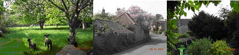
1.0 Summary The planning policy context Our aim will be to demonstrate to the Planning Inspectorate that this development fails to reflect both national and regional requirements in relation to the key issues of sustainability, conservation, biodiversity & environment and local amenity value. Our main source of evidence comes from the North Somerset Council (NSC) Local Replacement Plan but supported by a range of other documents for reference purposes. This document is laid out with sections 2-7 being our detailed proof of evidence supported by reference documents in sections 8-20 and Appendix 1 & 2. Main planning considerations The policies of the NSC Local Replacement Plan clearly seek to protect a village like Wrington from inappropriate housing development. In this case the proposal would introduce a scale and style of development on the edge of the village at odds with the character and pattern of existing development and the conservation area. Extending the build area on this scale intrusively into the conservation area will spoil the special character the area enjoys to today. There is no landscape proposal of a scale sufficient to mask the development, making it an inappropriate feature in its own right. The roads in Wrington were not built for modern traffic. The narrow lanes and high stonewalls are a special feature of the village as a whole. The introduction of additional vehicles would highlight the inadequacy of these lanes to accommodate more traffic. In order to provide a satisfactory access to the site it will be necessary to remove mature trees and lower part of the stone wall frontage, destroying this important feature of the conservation area and further highlights the intrusive nature of the proposal. The biodiversity of the site is underpinned by the type of habitat that wildlife is able to thrive in with ancient walls, mature trees & hedging, orchard and green pasture land, the removal of such will have a negative effect in the conservation area. There is no need for a housing development of this type in the village. North Somerset has an existing supply of housing land and encourages urban type development of this type to be concentrated on the 4 main towns, Clevedon, Weston-Super-Mare, Portishead and Nailsea. Wrington is not a town and can no longer sustain intensive urban housing developments such as that proposed without a detrimental affect on the village amenity and infrastructure. Pressure for development in Wrington is increasing with another application recently withdrawn at Richards Garage site within the village for 14 houses in a similar sized site. In addition the site itself is described by the developer as ‘Brownfield’ land. Evidence proves that a significant part of the site is not, and never has been a brown field. This once again demonstrates the fundamental unacceptability of development such as this proposal. If this development is approved it will set an extremely dangerous precedent, not just in Wrington, but for the numerous villages scattered across the North Somerset countryside which would be left vulnerable to high levels of intrusive housing development at a time when the NSC Local Replacement Plan is rightly seeking a more sustainable pattern of development, focused on the 4 main towns in North Somerset. Conclusion In conclusion, the proposal is clearly unacceptable in terms of policies of the NSC Local Replacement Plan. This fundamental conflict could not be resolved by the imposition of any conditions and therefore, in the absence of any other factors which might lend support to the proposal, it should be rejected. Wrington has seen considerable development over the past 25 years (see local map in Section 9 of this document) and intensive urban ‘anywhere housing’ developments such as that proposed by Linden Homes is not acceptable in a designated conservation area, nor is it sustainable as this development will certainly lead to another dormitory settlement with high levels of out-commuting. In this complex case we ask the Planning Inspectorate to focus on the issues that most concern the Wrington Residents Group as it is we and the village as a whole who will have to live with the consequences if this plan goes ahead. The key issues are:- The importance of the site in the conservation area has been overlooked or ignored by the appellants and North Somerset Council The site forms part of a vital ‘wildlife corridor’ in the village and is significant in terms of the local environment, ecology and biodiversity of the surrounding area The site sits within a high flood risk location It has a significant negative impact on the amenity value as a whole and to that of adjoining occupiers Developments of this nature are no longer sustainable within the village of Wrington Through our ‘Proof of Evidence’ as residents, we seek to provide the case why this application must be refused. The case we submit to the inquiry will be supported by witnesses to present the relevant evidence on the 6th June 2007 and throughout the duration of the inquiry. The information we have provided in this document is correct to the best of our knowledge as residents of Wrington. We would be grateful and reserve the right to submit any further evidence, should any emerge, at the inquiry, subject to agreement by the Planning Inspectorate. 2.0 Relevant history of Brook House We believe that this evidence is conclusive proof, supported by the maps of 1888 and 1903, that the orchard and paddock area clearly marked separately from the house and garden of Brook House has been an orchard since records began and never previously developed land. The open green space is still today an orchard with mature trees and greenery making a significant contribution to the character of the conservation area and the biodiversity of the site. It is clearly visible from the surrounding area. The paddock is still used today for grazing sheep. It’s hard to imagine anyone believing this is a ‘brownfield’ site and it would be hard to argue otherwise. A transcript of the history of the property is included in Section 20 of this document. The Commander was a well known, respected and valued member of the village community and throughout his life he maintained and preserved the character of the house and the surrounding grounds until poor health prevented him from doing so. In 1971, the Village of Wrington became a designated Conservation Area, Brook House and it’s gardens fell within this area of designation. Commander Lawder personally restored many of the boundary walls and outbuildings, as an active gardener he was also responsible for enhancing the land characteristics of the area through the preservation and planting of trees and vegetation. It was this planting and the maintenance of the site that has contributed much to how it stands today.
The North Somerset Council decision to refuse this application is one that is endorsed by village residents. That support has been reflected through 2 public meetings, over 70 letters of objection to the current scheme (copies of which are in Appendix 2), and the unanimous endorsement of resident’s objections by our own Parish Council. The application subject to this appeal is a slightly amended version of a previous application withdrawn by Linden Homes following similar local residents and NSC objections. The plan was refused by both North Somerset South Area Planning Committee and then again by the Planning & Regulatory Committee on 3rd January 2007. The history of the Brook House site is covered in the Desk Based Archaeological Report submitted by the developers. A number of additional comments are made here. The first concerns the assessment, which was made for English Heritage when the property was investigated for listing. Paragraph 3. On page 3 covers ‘Assessment of the special interest of the boundary walls’. Whilst there is evidence from the former owner that the walls were of contemporary date with the house, English Heritage would not pursue Listing for the house or the walls. However, note should be taken of the statement that concludes para 3., which says: “Under the present circumstances, they (the walls) fall within the Conservation Area, and are thus, like the house, afforded an appropriate level of protection, particularly as the Conservation Area is in part characterised by the presence of similar boundary walls throughout the village.” The conclusion of this report says: “This has left Brook House with an overwhelming C19 character which does not have sufficient special architectural or historic interest to merit designation in a national context. It is, though, a building which, along with its boundary walls, is of clear local interest which is reflected in its inclusion in the Wrington Conservation Area, which affords it an appropriate level of statutory protection.” Whilst North Somerset Council has agreed to the retention of Brook House and the outbuildings, the curtilage and dividing walls are not being afforded the appropriate level of protection, because permission has effectively been given to lower the frontage part of the curtilage walls in order to a) gain access for development and b) provide controversial additional visibility for road traffic, and to demolish almost all of the dividing wall. The second is included in the letter by the former owner, Cmdr M. Lawder, in which he presumes the date of the curtilage walls to be the same date as the walls of the house, which puts the date of the walls as 17th century, and therefore justifies their protection as significant historic structures within the Conservation Area because of their age. 3.0 Evidence on Conservation The Brook House site and considerations concerning Previously Developed Land, otherwise known as Brownfield Land. The Brook House site is subdivided into three parts, by an internal wall which subdivides the kitchen garden from the paddock/orchard, and by a fallen post and wire fence which divides the paddock/orchard into two parts, the smaller of which contains outbuildings, and the larger of which contains the mature trees and grass meadow. The subdivision is shown on the map in Section 9 and photographs of the post and wire fence are shown in Section 17. Consideration should be given to the validity of the proposed development as it is in either or both of 'not previously developed land' and 'land which is or has been used for agricultural purposes'. PPG3 rules were considered earlier in the progress of these appeals. PPS3 is also used as a reference PLANNING POLICY GUIDANCE 3: HOUSING: Annex C: Definitions: States 'Previously developed land is that which is or was occupied by a permanent structure (excluding agricultural or forestry buildings, and associated fixed structures)', and 'The definition excludes land and buildings that are currently in use for agricultural or forestry purposes.’ and 'The curtilage is defined as the area of land attached to a building. However, this does not mean that the whole area of the curtilage should be redeveloped.' PLANNING POLICY STATEMENT 3 Annex B Page 26 states 'Previously-developed land (often referred to as Brownfield land): Previously developed land is that which is or was occupied by a permanent structure, including the curtilage of the developed land and any associated fixed surface infrastructure. The definition includes defence buildings, but excludes: - Land that is or has been occupied by agricultural or forestry buildings. - There is no presumption that land that is previously-developed is necessarily suitable for housing development nor that the whole of the curtilage should be developed.' Point (1): The land is currently in use for agricultural purposes. Photographs are provided in Section 17 showing sheep grazing in the paddock/orchard in June 2006 and in April 2007. This should preclude the right to development under PPG 3 Annex C. Point (2): The land is occupied by buildings which are identified as a stable and a piggery in the Archaeological Desk Based Assessment submitted by the Developers, (Page 14 para 5.2.5).This is confirmed in the enclosed copy of the extracts from the 1895 Wrington Estate Sale Particulars in Section 9 of this document. Therefore, since this land is and has been occupied by agricultural buildings, then it should be excluded from development under PPG3 HOUSING Annex C Definitions, and under PPS 3 Annex B page 26. Point (3): Since at 1895 or earlier, the house now known as Brook House, previously known as Brook Cottage together with its kitchen garden have been fundamentally separated from the orchard/paddock by a stone wall which still exists. This wall divides the house and kitchen garden from the paddock/orchard, creating a separate curtilage for the paddock/orchard. This paddock/orchard contains the shed, stable and piggery shown on the 1895 map. There are therefore two curtilages, one containing the house known as Brook House, and the other being the paddock/orchard. The paddock/orchard has been used for agricultural purposes, having contained a stable and piggery, and is currently in use for agricultural purposes with sheep grazing therein. Point (4): Both PPG3 HOUSING Annex C Definitions and PPS3 Annex B page 26 states, in the first instance: 'The curtilage is defined as the area of land attached to a building. However, this does not mean that the whole of the area should be redeveloped', and in the second instance, 'There is no presumption that land that is previously-developed is necessarily suitable for housing development nor that the whole of the curtilage should be developed.' This land is unsuitable for housing development by virtue of its Conservation Area properties, the loss of ecological habitat both fixed and transient, the risk of flooding and the unacceptable measures needed to mitigate flooding and storm water problems, and the loss of green space in a rural setting, which is of major concern to Wrington residents. The matters are discussed elsewhere. It should also be pointed out that the proposed development does develop the whole of the curtilage(s), which is against the advice given in both PPG3 and PPS3. Point (5): A further argument concerns the further subdivision of the paddock/orchard by a post and wire fence during the 19th or 20th century as shown on the 1895 map. This post and wire fence still exists and is delineated on the latest Ordnance Survey maps. Photographs are included in Section 17. The post and wire fence creates a space, which can be considered as 'not previously developed land’ inasmuch as it has no buildings within it, and therefore takes this piece of land out of the category of 'Previously Developed Land, otherwise known as Brownfield Land'. Conservation Area Issues The Brook House site is within the Wrington Conservation Area, it therefore is entitled to be given consideration under NSRLP Policy ECH/3. This policy states that development will be permitted provided that it 'preserves or enhances'. i) the character or appearance of the area ii) features of special architectural or historic interest of the area; and iii) other elements of the townscape, including traditional buildings and public realm that make a positive contribution to the quality of the area's character and appearance. (iv) In the case of proposals for the demolition of buildings or structures that make a positive contribution to the character or appearance of a Conservation Area, there will be a presumption in favour of retention unless it can be demonstrated that there is no viable alternative use. These issues are now considered as follows: The character or appearance of the area The character and appearance of the Brook House part of the Wrington Conservation Area takes the current form: A double row house, part of which dates from the 1600's. Outbuildings, some of which also have considerable date. A pigsty on the same part of the site is shown in old maps. A curtilage wall, said by the previous owner who was a local historian to possibly have the same age as part of his house, and a wall sub-dividing the garden from the paddock/orchard, which is not in derelict condition. The curtilage wall is the first part of almost continuous walls into the centre of Wrington, and forms the gateway to the village when approached from the south. A mature green growing environment consisting of substantial trees and bushes. There are two trees, which at the time they were planted were rare species. They were planted by the owner with the intention of preventing later development on this site. The whole is therefore a small country estate, which contributes significantly to the historic environment, and to the green grown environment. It offers pleasant views within, into and out of the Conservation Area for the former and future owners Brook House, for neighbouring house occupiers, and for Wrington residents in general. It is appropriate to mention that the former owner allowed the annual Wrington Fete to be held in the paddock/orchard, and the splendid ambience was enjoyed by many hundreds of villagers over many years. To build an intensive development of 12 houses on this site will almost completely destroy the character and appearance of this Conservation Area as it stands today. To demolish any part of the curtilage and dividing walls will certainly destroy the character and appearance of this Conservation Area. Features of special architectural or historic interest of an area The site, including Brook House its outbuildings, surrounding and dividing stone walls, is of special architectural and historic interest. This is evident from the Desk Based Archaeological Report submitted by the developers, and from the re-assessment of the site for potential listing by or on behalf of English Heritage. The Desk Based Archaeological Report sets out the site history in detail, and a Summary and Conclusions appear on page 17 of the developer’s conservation and design statement a copy of which is in Section 15 of this document. The re-assessment for designation (listing) consideration on behalf of English Heritage of this site concludes that the buildings do not merit designation (listing) in a national context. It also says that the building (Brook House) along with its boundary walls is of clear local interest, which is reflected in its inclusion in the Wrington Conservation Area, which affords it an appropriate level of statutory protection. The North Somerset Conservation Officer’s comments 08 June 2006 against the earlier Planning Applications, (copy of this is in Section 16 of this document) whilst not reflected in later comments, also confirmed the importance of the House, its outbuildings, and both the internal and boundary walls. This document’s comments were: “ The special interest of this area of the conservation area emanates from the unspoilt large traditional orchard/open space. It forms an important visual setting to the conservation area, which contributes to views both in and out of the conservation area. The significant presence of trees in this bounded area also enhances the historic landscape and is an important green space before the start of the built environment. Removing these trees will also detrimentally affect this area. This development will not preserve or enhance the character and appearance of the area as the intensification of the open space will lead to the loss of its unspoilt rural character’. This is contrary to Policy ECH/3 (5.38) and PPG15 (4.14, 4.19) Recommendations: Only a small amount of development located to the west of the site will be acceptable in conservation terms. “ Although the North Somerset Conservation Officer’s later comments do not reflect the above statement, it is the opinion of the Wrington Residents Group that the above wording correctly interprets the situation with regard to the current Brook House development proposals a very little changed in terms of the developers plan from the original application that was submitted and later withdrawn to that of the current proposed plan. Whilst an attempt has been made by the developers to replace the existing grown environment, there is simply not enough room within the proposal for significant quality and stature of green growth. The consequence of this is that the aspects of this development will be transformed from a green grown environment to one of intensified housing, concrete, tarmac and cars, which will be further amplified by the removal of part of the curtilage wall, thus exposing the area to external view. This contravenes NSRLP Policy ECH/3 - Conservation Areas. A further consideration refers to ECH/3 paragraphs 5.36 and 5.37- ‘Conservation Area Appraisals.’ Since the Replacement Local Plan has been used as a reference for this development proposal, then paragraphs 5.36 and 5.37 are relevant. These sections cover Conservation Area Appraisals and North Somerset Council’s proposals for appraisals of a number of Conservation areas. Since the appraisal of any one of the 35 Conservation areas could have an impact on any planning applications in that particular area, then no Conservation Area planning applications should be considered until after the appraisal has been done. North Somerset Council should therefore appraise the Wrington Conservation Area before any planning permission is granted within the conservation area, and not retrospectively. Consultation with the public within the Conservation Area (5.36) should take place, and account should be taken of all of the ten of the criteria listed in 5.37. Dealing specifically with DCLG document PPG 15 Section 4, this document refers to an 'area', which we believe means the whole of the Brook House site. The following objections are based on, and refer to the DCLG document headed Planning Policy Guidance 15: Planning and the historic environment....Pages 1-7. 4. Conservation Areas 4.1 says 'Section 69 of the Act imposes a duty on local planning authorities to designate as conservation areas any 'areas of special architectural or historic interest the character or appearance of which it is desirable to preserve or enhance.' The emphasis here is therefore on a conservation area. In accordance with Section 69 of the Act, the Brook House area (that area encompassed by and including the external curtilage walls) has previously been designated as a Conservation Area, which signifies that it has either or both of 'special architectural or historic interest the character or appearance of which it is desirable to preserve or enhance'. This is the key statement within this analysis of whether or not NSC is conforming to Section 69 of the Act and the guidance written in PPG 15. It our contention that NSC will not conform with this if it accepts the current development proposals of Linden Homes, because the proposals fail to 'preserve or enhance the character or appearance' of the area. It says in 4.1 that conservation area designation is the main instrument available to authorities to give effect to conservation policies for a particular neighbourhood or area. The keyword here is 'area' which encompasses not only the immediate surroundings of Brook House itself, but also the wider context of the garden, the area of the outbuildings, the previously undeveloped paddock or orchard, the stone curtilage walls and the internal dividing wall. Para 4.1 goes on to say that designation introduces a general control over the demolition of unlisted buildings and provides the basis for policies designed to preserve or enhance all the aspects of character or appearance that define an area's special interest. This does not therefore exclude the internal walls between the garden and the paddock/orchard, much of which it is proposed to demolish. We suggest that it might be necessary for permission to be sought and granted to demolish the structure, which is the internal dividing wall between the garden and the paddock/orchard, which has historic value and is part of the character of the area. 4.2 says 'It is the quality and interest of areas, rather than that of individual buildings, which should be the prime consideration in identifying conservation areas. There has been increasing recognition in recent years that our experience of a historic area depends on much more than the quality of individual buildings - on the historic layout of property boundaries etc...' Therefore the envelope enclosing Brook House and its garden, its outbuildings in their own delineated area, and the paddock/orchard distinctly delineated from the above, all enclosed in curtilage walls should be considered as the area, the quality and interest of which is at the heart of this argument. 4.2 goes on to say that 'Conservation Area designation should be seen as the means of recognising the importance of these (the described) factors and of ensuring that conservation policy addresses the quality of the townscape in its broadest sense as well as the protection of buildings.' In the case of the Brook House development proposals, the only conservation that is proposed is the retention of the existing house, a minimal part of the internal wall, one of the outbuildings and part of the external curtilage wall. Little regard has been taken of the historic internal curtilage wall between the garden and the paddock/orchard, evident on maps since 1838, and little regard has been taken of the rural grown environment containing substantial trees and green pasture (photographic evidence already provided). Any argument concerning the internal wall being 'out of view' is unfounded. Adjoining residents see this wall every day from their windows. The replacement vista in the development proposals, which would be houses, garages and a road, contravenes PPG 15 POLICY and NSC POLICY ECH/3 inasmuch as it fails to address the townscape of the area. 4.4 say '...The definition of an area's special interest should derive from an assessment of the elements that contribute (detract) from it. Conservation areas vary greatly, but certain aspects will almost always form the basis for a coherent assessment: the topography - for example thoroughfares and property boundaries - and its historical development, the archaeological significance and potential; the character and hierarchy of spaces;....the quality and relationship of buildings in the area and also of trees and other green features.' Our contentions here are that the character and hierarchy of the Brook House space have not been given adequate consideration in the proposed plans, (pleasant green space is to be replaced with intensified housing) nor has the quality and relationship of buildings within the area been properly considered, (the style and construction of the proposed buildings conflicts with many of the properties in the immediate area), nor have the trees and green features been properly considered (proposals to fell the majority of the trees and green features and pasture, and replace them with houses, concrete, tarmac and cars). Policies for conservation areas 4.9 This says 'Section 71 of the Act places a duty on local planning authorities to formulate and publish proposals for the preservation and enhancement of conservation areas'. There is no evidence of any NSC proposals for the preservation and enhancement of the Brook House conservation area, taking into account all of the buildings and associated structures including the curtilage walls and the dividing wall between the garden and the orchard/paddock, and including the trees and other green features referred to in 4.4. Our perception is that there is an absence of duty, which allows the stakeholders of this development and other developments in Wrington, to submit intensive developments in sensitive Conservation Areas which have a well-documented and lengthy history, and which contribute greatly to the local area by virtue of their historic and green environment. The 4.9 clause, 'Clear assessment and definition of an area's special interest and the action needed to protect it will help generate awareness and encourage local property owners to take the right sort of action for themselves', might have been born out if efforts had been made by NSC to encourage interest in the 'enhancement and preservation' of this conservation area, before the advent of an invasive planning application. 4.10 says 'The Act requires proposals for the preservation and enhancement of a conservation area to be submitted for consideration at a 'public meeting' in the area, but wider consultation will almost always be desirable, both on the assessment of special interest and on proposals for the area.' There is no evidence that this has taken place in the case of the Brook House site, the result of which is that NSC is now bombarded with objections to an over intensive and invasive planning application. 4.10 go on to say, 'Consultation should be undertaken not only with local residents and amenity societies but also with chambers of commerce, public utilities, and the highway authority'. In the case of Brook House, NSC may well have consulted with public utilities and the highway authority, and almost certainly with developers, but they have either overlooked or ignored their responsibility to consult with local residents and amenity societies, both before a planning application was submitted, and during the course of considering a submitted planning application. 4.12 says 'Once policies for a particular area have been formulated, they should be made available to local residents and businesses in leaflet form, setting out clearly why the area has been designated, what the specially valuable features are etc'. It goes on to say 'Without such information, the support of local residents is not likely to be realised to the full'. This is exactly what has happened in the case of Brook House. Not only have local residents and amenity societies been failed by NSC with absence of information about policy for Brook House, but planning applications have been encouraged that fail to comply with the 'preserve and enhance' statements. 4.13 says 'Local planning authorities are asked to consider setting up conservation area advisory committees, both to assist in formulating policies for the conservation area (or for several areas in a particular neighbourhood) and also as a continuing source of advice on planning and other applications which could affect an area'. Such committees are desirable for the Wrington Conservation Area before planning applications can be considered. 4.13 goes on to say 'Committees should consist mainly of people who are not members of the authority; local residential and business interests should be fully represented in addition to local historical, civic and amenity societies, and local chambers of commerce etc'. Use of planning powers in conservation areas 4.14 says 'Section 72 of the Act requires that special attention shall be paid in the exercise of planning functions to the desirability of preserving or enhancing the character or appearance of a conservation area. The desirability of preserving or enhancing the area should also, in the Secretary of State's view, be a material consideration in the planning authority's handling of development proposals which are outside the conservation area but would affect its setting, or views into or out of the area.'
This particular section of the Act has a great deal of relevance in the case of the Brook House proposals as follows: i) apart from the saving of the entities of Brook House, one of its outbuildings, a minimal section of the internal wall, and part of its external curtilage wall, the development proposals ignore most of the length of the internal structure being the historic wall delineating the garden from the orchard/paddock, which appears in continuity on maps dated 1838, 1888, 1895, 1903, 1959, and the current OS map, as well as the aerial photograph of April 1971. All of these maps appear in submissions by the Avon Archaeological Unit, which accompanied the planning applications. The development proposals also disregard the non-structural appearance of the conservation area, being the considerable tree and other green growth, which includes the pasture, that constitutes the character and appearance of the area. This disregard is manifest in the replacement of the ancient internal wall and the growing trees and other greenery, with a compact development of houses, tarmac, concrete and cars, with inadequate space left for replacement. The requirement in Section 73 of the Act as stated above is therefore not met. ii) 'The desirability of preserving or enhancing the area should also...be a material consideration in the planning authority's handling of development proposals which are outside the conservation area, but would affect its setting, or views into or out of the area.' One of the main objections from the Wrington Residents Group, some of whom have properties adjoining the Brook House curtilage, and from villagers who know the site, who have used the site when it was made available as an amenity by the Late Cmdr Lawder, and including those who pass it in transit, is that the proposals will not enhance or preserve the character and appearance of the area. A comment from an adjoining resident reads ‘In my own case, my wife and I spend a large part of our time indoors in rooms which face the paddock/orchard and outside on a patio adjacent to the curtilage wall, and we have been accustomed to the character and appearance of this conservation area from the outside. The development proposals have absolutely nothing to offer in enhancing or preserving the character and appearance of this conservation area from our view into the site. The requirements in Section 72 of the Act are therefore not met in this respect either.’ 4.19 says 'The Courts have recently confirmed that planning decisions in respect of development proposed to be carried out in a conservation area must give high priority to the objective of preserving or enhancing the character or appearance of the area.. If any proposed development would conflict with that objective, there will be strong presumption against the grant of planning permission, though in exceptional cases the presumption may be overridden in favour of development which is desirable on the ground of some other public interest.'
We believe that the proposed development is in conflict with the objective of preserving or enhancing the character and the appearance of this area, and therefore there should be a strong presumption against the grant of planning permission. A decision to approve these proposals would contravene previously confirmed legal arguments. 4.20 says 'As to the precise interpretation of 'preserve or enhance', the Courts have held..... that there is no requirement in the legislation that conservation areas should be protected from all development, which does not enhance or positively preserve. Whilst the character and the appearance of conservation areas should always be given full weight in planning decisions, the objective of preservation can be achieved either by development which makes a positive contribution to an area's character or appearance, or by development which leaves character or appearance unharmed'.
We do not believe that the character and appearance of the Brook House site has been given full weight before the planning decision. Insufficient consideration has been given to the growing environment and the views into and out of the conservation area. We do not believe that the proposed development makes any contribution to this conservation area's character or appearance (accepting that the renovation of Brook House itself is a positive contribution), and neither does the proposed development leave the character and appearance unharmed. The character and appearance of this conservation area will be harmed considerably and beyond recognition by the destruction of wall structures, both external and internal to the site, and by the removal of most of the components of the grown environment. A decision to approve these applications would there contravene previously confirmed legal arguments. We would like to add at this stage that the developer's Planning Statement (3.12) admits to changing the character of the site, but states that it will not prejudice amenities of the adjoining properties. There is no doubt what so ever that he amenities of adjoining properties are prejudiced, and therefore the developer’s statement is incorrect. Conservation area control over demolition 4.25 says that 'Conservation Area designation introduces control over the demolition of most buildings etc.. Applications to demolish must be made to the local planning authority etc.'
Trees in conservation areas 4.38 says 'Trees are valued features of our towns and countryside and make an important contribution to the character of the local environment. Under Part VIII of the principal Act, local planning authorities have the power to protect trees and woodlands in the interests of amenity by making tree preservation orders. In addition to this general power, authorities are under duty to make provision for the preservation and planting of trees when granting planning permission for the development of land. They do this by a combination of planning conditions and tree preservation orders.' At the present time there appear to be no planning conditions or tree preservation orders in place to protect the trees in the Brook House conservation area, which implies that the authority is satisfied with the recommendations in the developer's arboricultural report to fell all except two of the existing trees, given the layout proposed, as quoted by the NSC landscape officer. The powers given to the local authority to preserve or protect the existing trees provided by the Act, have either been overlooked or ignored which places the local community in general, and the adjoining property owners in a position of having to defend itself against over development in a conservation area, where national and local policies should fall into place to protect the area from intensive development. 4.39 says 'Many trees in conservation areas are the subject of tree preservation orders, which means that the local planning authority's consent must be obtained before they can be cut down, topped or lopped. In addition to these controls, and in view of the contribution that trees can make to the character and appearance of a conservation area, the principal Act makes special provision for trees in conservation areas which are not subject the subject of tree preservation orders. Under section 211, subject to a range of exceptions, (including small trees and ones that are dead, dying or dangerous), anyone proposing to cut down, top or lop a tree in a conservation area is required to give six weeks notice to the local planning authority etc. Penalties for contravention, which may include a requirement to replant, are similar to those for tree preservation orders'. Our understanding of the situation in the Brook House conservation area and the developer’s proposals is that no attempt has been made to value the contribution that the trees make to the character and appearance of the conservation area. Furthermore, the arboricultural report from the developer's consultants which aims to fell most of the trees, and build over the others excepting two, appears to have been accepted, and yet we witness trees with healthy growth from every day when we look into the site. Section 4.39 which we are now considering says that the principal Act makes special provision for trees in conservation areas which are not the subject of tree preservation orders. We believe it is incumbent upon the local authority to invoke these special provisions, or to invoke tree preservation orders on the trees in the Brook House conservation area, in order to protect them, and in order to preserve the character of the local environment as set out in 4.38. 4.40 says 'When considering whether to extend protection to trees in conservation areas, local planning authorities should always take into account the visual, historic and amenity contribution of trees. In some instances new plantings may be desirable where this would be consistent with the character and appearance of the area'. As has already been stated repeatedly above, the trees in the Brook House conservation area play a very important part in the visual, historic (some of these trees are probably 50-100 years old) and amenity contribution to the area. This contribution has therefore to be taken into account according to 4.31. With regard to the statement that 'In some instances new plantings or replanting may be desirable where this would be consistent with the character and appearance of the area.’ it is obvious that replanting will have minimal effect on the appearance and character of the conservation area, as there is simply not enough room to accommodate adequately sized trees. The result is a conservation area, which has lost its character and appearance, and has not been preserved or enhanced according to the general requirements of PPG 15, which by default is the responsibility of the local authority. English Heritage, in its document 'What is a Conservation Area' says 'The special character of these areas does not come from the quality of their buildings alone. The historic layout of roads, paths and boundaries; characteristic building and paving materials; .....public and private spaces, such as gardens, parks and greens; and trees and street furniture, which contribute to particular views - all these and more make up the familiar local scene. Conservation areas give broader protection than listing individual buildings: all the features, listed or otherwise, within the area, are recognised as part of its character.' Wrington Residents Group have commissioned an independent tree survey for the whole of Brook House site which is due to commence on Monday 14th May 2007. This will be referred to as evidence at the inquiry under section 13 of this document. Conservation responses from Wrington Residents A recent Wrington Parish Plan Questionnaire conducted on behalf of The Wrington Parish Plan Steering Group produced the following results from respondents under the heading of ENVIRONMENT. The scale of replies ranged from 1=most important, to 5=least important: Asked 'How crucial are the following issues to you?' (1) Conservation of the parish landscape character: 75% replied 'most important', category 1. A further 17% answered to the next most important category 2. (2) Preservation of trees and hedges: 70% replied 'most important', category 1. A further 19.5% answered to the next most important category 2. Objections sent to North Somerset Council Many letters of objection were sent to NSC. The majority were based on loss of Conservation Area and green grown environment. We accept that the retention of the house called Brook House, one of the outbuildings and part of the curtilage wall goes part of the way towards satisfying the Conservation Area requirements, but we do not accept that building an intensive 12 house development, after having removed part of the curtilage wall, an internal wall and the green growing environment, enhances or preserves the character of this Conservation Area. The development proposals should therefore be refused. Flooding issues Flooding issues are complicated, and the theoretical analysis of flood risks is generally beyond the scope of anyone but specialists on the subject. However, one fact is that Brook House and the properties adjacent to the Brook House site are currently under notification of being within a high flood risk area. A letter was sent to North Somerset Council by Mr R Bartlett, a resident in an adjacent property, voicing concerns with regard to flood risk. The substance of this letter is copied below: "On the matter of FLOODING with respect to the Brook House site, I would like to raise the following points. Please understand that we live adjacent to the Brook House site on the south side. I believe that that these matters are covered in PPG25 and in NSC RLP GDP/4. (a) In February of this year 2006, we received a notice from the Environmental Agency informing us that we were in a Flood Risk Area. This is not surprising because we sit at the bottom of a catchments area that extends back to the village of Redhill, and is close to a constriction in the flow of Rybrook around the bridge in Silver Street. Formerly there was an adequate flood plain below the bridge, but this has all been built on. (b) In the applicant's Preliminary Flood Risk Assessment provided for this site there are many references to the possibility of flooding to the site. These are based on theoretical models of what might happen in the future based on the 100-year flood (including climate change). A reference is made in 'Conclusions and Recommendations' para 4.8, to flooding in the area at Brook Cottage, in 2001. Brook Cottage is only a short distance from Brook House along Silver Street. What is not mentioned is the reality of at least two other floods in this immediate area within the last 40 years, which have directly affected Brook House. The most recent of these was on 19th January 1999, when many local residents observed floodwater in Silver Street beside the Brook House site, and entering into the grounds of Brook House. The evidence of this flood and its impact on Brook House is still to be seen on internal walls of Brook House, a fact that was recently quoted by the NS Councillor for Wrington at a previous Committee meeting. Further evidence I have read today in the archives at Somerset Records Office of the late Cmdr Lawder, the occupier of Brook House. He says in his notes dated 23rd February 1999: 'The flood does not seem to have had any ill effect except that a thin layer of mud needs to be removed from the bottom of each cupboard'. The other flood was in August 1968, when the whole of this immediate area was under water in a well-documented flood incident. My wife, who has lived in this property for 43 years, remembers it well. Our property is adjacent to Brook House on the south side. The road outside our property was about 12 inches deep, and we believe that Brook House was flooded to a considerable depth. This belief is based on the fact that during the January 1999 flood, less water was observed outside our property than was observed in 1968. A greater depth outside our house accords with a greater flood level in and around Brook House. There may be other significant local flooding incidents that have occurred, but to be able to recall 3 incidents within 40 years puts the actual rate of incidence at 7.5 per 100. At least one of these incidents occurred before the available flood plain below the bridge was swallowed up with developments, and in the 1999 incident, houses downstream of the bridge are known to have flooded. The Environmental Agency seemed to be unaware from the planning documents provided to them, of actual flooding incidents that have affected Brook House.
There are many 'ifs' and 'buts' in the Preliminary Flood Risk Assessment, not the least being the reference to the essential maintenance of watercourses, gullies, culverts and gratings. Since the reality is far from the theory in these matters, then the actual flood risk is could be considerably greater. Drainage and flooding The proposal to increase the base height of the houses in order to accommodate the flood risk would suggest that this will cause a flood water flow from the centre of the site outwards. It is also noted that there may be a substantial loss of ground absorption capability because the site will have been covered in concrete and tarmac. Now since adjoining and the properties will lie below this raised base height, this means that we will receive floodwater directly from the development, resulting in flooding to those properties. This is not acceptable. With regard to the attenuation of surface storm water with suggested underground storage, there are two questions: (a) where would the underground storage be sited, and is there any room for this storage within the site. (b) how can you discharge water from the attenuation network to the headwall of a bridge into an already overloaded brook unless the whole site is raised to an unacceptable height to generate adequate flow. It would appear that the water flow is otherwise finely balanced. Storm water attenuation network may fill, not only from the site storm water, but also from the 7.5 in 100 floods left as residual, and also possible as a reversal from the proposed outflow to the brook. The raising of the height of the houses (minimum 600mm) will cause further intrusion, but is it not likely that the base height of the houses will have to be further increased to accommodate the storm/flood water underground system below the foundations, which suggests that the house tops will reach some towering height above the surrounding properties especially those proposed with three storeys. The proposal already presents the possibility of two story dwellings dominating adjacent bungalows just over the wall in what is today a designated as a Conservation Area. The whole of the development will stand out above surrounding properties. (Policy ECH/3) This further strengthens our arguments on Conservation Area issues and the lack of measures so far proposed to accommodate flood and storm water risks. The proposed development will result in erosion of the special features of the area and worsening of the character and appearance of the Conservation Area. From the actual flood incidence rate reported above (7.5 in 100), in order to establish the suitability of land at Brook House, Table D.3 (attached) will be used, together with tables D.1, and D.2. Using table D.1, and the 7.5 in 100 rate, Brook House falls into Zone 3a High Probability. Using table D.2, the proposed development falls into Classification 'More Vulnerable' i.e. Buildings used for: Dwelling houses. Cross referencing 'Zone 3a' and 'More Vulnerable' gives us 'Exception Test Required'. The Exception Test is described in D9 a), b), and c). We do not believe that these conditions are met, in particular c) where it has not been demonstrated that the development will be safe, without increasing the flood risk elsewhere, and the overall flood risk will not be reduced. In fact the reality is that the Brook House site is a Functional Flood Plain for water overflowing from Rye Brook upstream from junction of Silver Street and Rickyard Road. It is the last undeveloped part of the Rye Brook flood plain before the Brook emerges downstream in open fields. All the other parts of the flood plain have been gradually swallowed up by development. Garstons, and The Glebe were all open flood plain until recent years. Since Brook House is therefore in Zone 3b 'The Functional Flood Plain', then when cross-referenced with 'More Vulnerable' in table D3, the recommendation is that 'Development should not be permitted’. Brook House : Trees in the Conservation area. The trees in the Brook House Conservation Area form an important part of the local environment, the character and appearance of which it is desirable to preserve or enhance. They make a positive contribution to the quality of the area's character and appearance as referenced in NSRLP Policy ECH/3 Conservation Areas i) and iii) The Arboricultural report provided by the developers recommends felling or removal of 16 out of 22 trees surveyed for a variety of reasons. This suggests that 16 trees are not worth preserving or any corrective action taken improve their health and longevity. Photographs included in section 17 of this document show both internal and external views of the trees and the contribution they make to the local environment. The photographs do suggest an alternative view concerning the health of these trees. Horse Chestnuts T10, T12 and T18 for instance appear to be in good health from the photographs. The arboriculturalist's comments 'limited chance to develop to maturity' against these trees and others surely means that they do have a chance, and from that point of view does this not warrant their protection and preservation. These trees are irreplaceable other than in the very long term. It will probably be 20+ years before replacements would achieve the same stature, even if there were enough space for the replacements to be planted, which there is not. In addition, the trees and hedging on the western boundary have not been surveyed. The survey simple reports, ‘dense trees, bushes and undergrowth’. This area is not only significant for wildlife, but it also serves as a significant amenity with a natural, living boundary for adjoining occupiers. Two further points should be noted; both concern the previous owner Cdr Michael Lawder. The first is that it is known by a number of residents that Cdr Lawder some years ago planted at least two trees, which were of rare species at the time of planting, with the deliberate attempt to thwart any future development on his land. The second is that Cdr Lawder conferred the benefit of this shady open space onto the village for many years when he allowed the Annual Wrington Village Fete to be held in the paddock. These memories remain strong in the minds of hundreds of villagers who both organised and visited events at the Fete. Some may find it distressing that intensified housing might swallow up the paddock. Some photographs are included in Section 17. Wrington Residents Group conclude that in terms of conservation issues the proposed plan falls well short of planning policy and what any responsible owner of property in a designated conservation area is expected to comply with as a minimum. 4.0 Evidence regarding Sustainability The Government website www.sustainable-development.gov.uk gives the following definition of how sustainable development can help to achieve a Sustainable Community. Sustainable communities should be: Well run - with effective and inclusive participation, representation and leadership. Environmentally sensitive - providing places for people to live that are considerate of the environment. Well designed and built - featuring a quality built and natural environment. Well connected - with good transport services and communication linking people to jobs, schools, health and other services. Thriving - with a flourishing and diverse local economy. Well served - with public, private, community and voluntary services that are appropriate to people's needs and accessible to all. Fair for everyone - including those in other communities, now and in the future With the existing level of housing in the village, Wrington is already failing to be “Well Connected” by public transport, and it is not “Well Served” by the current levels of shops and services.
Employment The main employment area in the village of Wrington is at Havyatt Industrial Estate. Currently trading there are the companies Burnett & Hillman; Travis Perkins; Dewey Waters; Butcombe Brewery and PJ Hare. There are also 7 new industrial units recently built, 3 of which are currently unoccupied. Recent analysis suggests that there are approximately 150 people employed in this area (including 17 in the new units) – 35 of these in total are resident in Wrington. Barton Wilmore letter (copy in section 19 of this document) dated 15 December 2006 referring to employment states: “Employment sites are generally developed with a footprint of 40% i.e. 40% of the site will be covered by buildings. As the site extends to 1.4 ha or 14,000 sq metres, the foot print of development would be expected to cover 5,600 sq metres (about 60,800 sq ft). Normal job density for B1a, B1b and B1c is 20 sq metres per job. This site could therefore provide 280 jobs on site. Clearly if the buildings were two storey then it could provide of the order of 500 jobs.” Compare these figures with the reality: There are 7 new units in total, 2 are still being advertised to let with a total sq feet of 8,287 sq. ft. These figures are taken from the letting agents own advertising board. Therefore calculated on a pro rata basis the total sq ft of these new units will be in the region of 29,000 sq ft. It will probably be a lower figure, as some units are smaller. This is considerably less than the 60,800 sq ft quoted by Barton Wilmore. Furthermore, the 4 units already occupied employ 17 people only. A long way from the 280 claimed by Barton Wilmore. The figures obtained from these business units w/c 30th April 2007 were as follows: Existing businesses Dewey Waters Light industrial manufacturing glass fibre tanks and enclosures. Employ 32 persons of which 6 are Wrington residents the other 26 commute into Wrington Burnett & Hillman Light industrial design and manufacture of high quality hydraulic hose fittings Employ 50 persons of which 20 are Wrington residents the remaining 30 commute into Wrington Travis Perkins Builders Merchants Employ 6 persons of which 1 is Wrington resident the other 5 commute into Wrington Butcombe Brewery (most recent business to move to Wrington in 2005) Brewers Employ 25 persons of which non-are residents of Wrington, all commute into Wrington PJ Hare Light industrial design and manufacturing of industrial press machines. Employ 20 persons of whom 3 are residents of Wrington the remaining commute into Wrington New business units Unit No 1 Not occupied Unit No 2 Not occupied Unit No 3 Accountants Employ 3 - 4 people all commute into Wrington Unit No 4 Not occupied Unit No 5 Warm Glass Employ 5 persons Unit No 6 Employ 3 persons Unit No 7 Employ 5 persons all commute into Wrington Summary Total number of employees including new units = 150 persons Total number of employers existing units = 133 persons Total number of employees new units = 17 persons Total number of Wrington residents employed = 35 persons Total number who commute into Wrington = 115 persons This information is further proof that Wrington is not today or likely to be in future, an area of significant employment opportunities. Considering that many of the jobs occupied in the village are relatively low skilled, the proposed housing development and current housing rates in excess of £300,000 for a 3 bedroom house makes it even less likely that the occupants would be working in Wrington. Out Commuting, Parking and Public Transport Wrington already has high levels of out commuting with people travelling mainly to Bristol and Weston-Super-Mare for employment. It is reasonable to assume that the occupiers of the proposed development at Brook House would be similar to existing residents of Wrington i.e. they would probably have 2 cars, and they would need to leave the village to reach their place of work. Evidence from the Parish Questionnaire and in addition a survey conducted on 6th May 2007on the two most recent housing developments in Wrington at Garstons Close and Asbury’s (copy of which is in section 10 of this document) indicate that not only are there high levels of out-commuting but in terms of parking, less than 26% of households use their garage for parking. This supports concerns of residents that the developer has under estimated the parking needs a development of this type in reality needs. In addition from the same survey the ratio of car ownership per household is 2:1. Therefore as the developer has allocated 15 of the total 27 parking spaces to be garages, leaving 12 other parking spaces, in reality this will lead to an overspill of 11 vehicles needing somewhere else to park. This does not take into consideration any visitors to the site. Evidence from the same survey also confirms the high levels of out-commuting with 90% of those adults working or in higher education commuting out of the village and all using a car. Combine this with the number of people entering the village being 86% of the local employment surveyed paints a picture of high levels of commuting, supporting the view that the proposed housing development will only serve to compound an increasing problem in terms of our narrow lanes and road infrastructure sustaining this and other similar types of intensive development. Existing public transport facilities for the village are infrequent, unreliable and expensive. For commuters needing to get to Bristol there is only one choice, leaving at 7.11 a.m., taking a long route via the airport, Felton and Winford arriving in Bristol 1hr 10 minutes later. Typically, less than 5 people get on the bus in Wrington at this time. The service is viewed as unreliable because in a typical month the bus can simply be cancelled (not delayed) at least once, which leaves people either stranded in town or unable to get to work. A similar situation exists for those wishing to get to Weston-Super-Mare. There is one bus suitable for most commuters leaving at 7.30 am and going through Langford, Churchill, Sandford, Winscombe and Locking, finally getting to Weston 50 minutes later. A one-way trip (as returns are not available early in the morning) costs £7 to either Bristol or Weston. It should be no surprise that most commuters travel to work from Wrington by car. The other possibility for getting to Bristol or Weston would be to go by train from Yatton 4 miles away. As there are no bus services from Wrington to Yatton, this would also involve a car journey. Again this is further evidence of an isolated village in terms of public transport the implications of any additional housing development simply adding to the number of vehicles travelling in and out of the village. Traffic entering and leaving Wrington A survey conducted on Tuesday 1st May 2007 provides some insight into the level of in and out commuting currently taking place in Wrington. The four main gateways to the village were monitored for traffic movement, Branches Cross, Cox’s Green, Beam Bridge and West Hay Road. The monitoring took place between the hours of 7.00am - 9.00am produced the following relevant results. Total number of cars leaving the village = 691
A sample at Branches Cross measured sole occupancy with the following results. 87% of all private cars leaving the village were sole occupancy 69% of private cars entering the village were sole occupancy
This evidence proves that there is already a high level of out-commuting and supports the case that most of the employment opportunities in the village are occupied by people who live outside the village further increasing the levels of people entering the village by private car. This is in conflict with the aims and objectives of the Local Replacement Plan policy H/7. A new intensive development in Wrington such as the one proposed at Brook House will simple compound the problem. Existing Shops and Services Wrington has a basic range of shops including an off-licence, post office, chemist, small food store, and a hardware store. Most residents are dependent on travelling by car to supermarkets in Yatton, Clevedon, Weston or Bristol. All of the above is likely to lead to high levels of: Car journeys to access shops and services Out commuting by car for people to reach their place of work or public amenities And it will also lead to parking problems within the development, as people will have more cars than there are parking spaces. We have already seen the results of housing development with insufficient parking in the village (The Glebe) – Cars parked all along the road, people unable to park near their houses, and an unattractive environment that would not fit the Conservation Area. Policies North Somerset Council’s (NSC) Joint Replacement Structure Plan (JRSP) gives guidance on how to achieve Sustainable Development. Policy 1 has some guiding principles for development. Section 4 “Providing for the housing and social needs of the population by residential development of a mixture of types, in locations with convenient access by means other than car to employment, services, facilities and open space.” Section 7 “Promoting more sustainable transport and securing long term shifts in travel behaviour by directing development to locations which have good public transport access or where practical opportunities to achieve it are demonstrated” NSC Local Plan Policy H7 states that development in a village like Wrington would be permitted, provided that the proposals: “would not lead to urban housing needs being met in locations outside the four main towns where employment opportunities are more limited and which would add to or contribute to creating a dormitory settlement with high levels of out-commuting.” Given the current levels of shops, services, employment opportunities and lack of suitable public transport this development will undoubtedly lead to: An increase in out-commuting by car An increase in the amount of car journeys to access shops and services
5.0 Evidence regarding Environment and Biodiversity
At the outset, the developers have recognised that this planning application and its approval are intrinsically linked to the importance and relevance placed upon this site with regard to its biodiversity and trees. It is our view that the developers approach has had two perspectives; the first of these has focussed upon the need to demonstrate that the development of the site will have little or no impact upon the biodiversity and trees that occupy the site. The second element of their approach has been to devalue the potential of this site with regard to its biodiversity and tree value, a position, which prompted one of the Linden Homes team to comment that it was of ‘no ecological value’. Whilst the developers approach to assessing the biodiversity and trees on the site can be described as open, and is assessed as having ‘exceeded the recommended survey effort required by best practice, carried out in the appropriate weather and season, using competent staff and correct equipment ’ we are of the view that the full value of the data generated has not been given the required levels of consideration by them. We are also of the view that in formulating their refusal response to this planning application, North Somerset Planning Officers have failed to give full regard to the significance and importance of the biodiversity of this site and the preservation of its trees. We believe that this is an important oversight, not least because of the responsibilities placed upon the authority by the ‘Natural Environment and Rural Communities Act 2006 which In Section 40 (paragraph 1) of the act states that: ‘Every public authority must, in exercising its functions, have regard, so far as is consistent with the proper exercise of those functions, to the purpose of conserving biodiversity’. In setting out this requirement the Act describes a public body as including ‘a local planning authority’. It places specific responsibilities upon the authority which include its duty to, ‘take such steps as appear to the Secretary of State to be reasonably practicable to further the conservation of the living organisms and types of habitat included in any list published under this section, or ‘promote the taking by others of such steps’. The Act (Paragraph 99c) states that the fact that where an areas ‘flora, fauna or physiographical features are partly the product of human intervention in the landscape, does not prevent it from being treated, for the purposes of any enactment (whenever passed), as being an area of natural beauty (or of outstanding natural beauty)’. It is our view that this particular piece of land, from an historical, conservation and biodiversity perspective can only be considered to be such a piece of land. The Wrington Residents Group is of the view that the developers arboriculture and ecological surveys have failed to satisfactorily address the environmental and biodiversity issues associated with this unique and conserved site. It is also our opinion that in refusing to grant planning permission to the developers that North Somerset Council have relied upon the policies set out in the North Somerset Local Replacement Plan. In limiting themselves to the application of the Local Replacement Plan to this particular application we believe that both legislative and regional guidance in relation to biodiversity and trees have been overlooked or ignored. In presenting this part of our case the Wrington Residents Group will seek to demonstrate that this should not have been the case and if permitted produce a range of additional evidence which will reinforce our views. This evidence will include direct reference to existing legislation, reference to local guidance including the North Somerset Biodiversity Action Plan and the production of independently commissioned arboriculture and ecological assessments of the site. Context Whilst the ‘Natural Environment and Rural Communities Act 2006 establishes a legislative framework through which local authorities are expected to deliver their obligations, additional National and Regional guidance establishes much of the context through which the biodiversity and trees of a site should be considered when dealing with planning applications. This guidance is more explicit and before moving on to specific issues regarding this particular application it is appropriate to reflect upon the various standards and expectations that it sets out. At a National level ‘Planning Policy Statement 9: Biodiversity and Geological Conservation establish the standard that should underpin all such development. ‘PPS9 sets out planning policies on protection of biodiversity and geological conservation through the planning system’ and ‘…. may also be material to decisions on individual planning applications’. PPS9 advises us that the Government is committed to, ‘conserving and enhancing biological diversity in England, together with a programme of work to achieve it. It includes the broad aim that planning, construction, development and regeneration should have minimal impacts on biodiversity and enhance it wherever possible ’. The document sets out a number of high-level objectives, which are: - to conserve, enhance and restore the diversity of England’s wildlife and geology to contribute to rural renewal and urban renaissance by: The guidance details how these objectives might be achieved and includes specific reference to development. These particular references include the need to ensure that there is an enhancement of ‘….biodiversity in green spaces and among developments so that they are used by wildlife and valued by people, recognising that healthy functional ecosystems can contribute to a better quality of life and to people’s sense of well-being’ and that ‘developments take account of the role and value of biodiversity in supporting economic diversification and contributing to a high quality environment’. As a residents group we do not believe that these objectives have been addressed, the density of the development and the associated removal of trees and hedgerows clearly result in the destruction of the existing environment do not do anything which will enhance the character of the area or address the biodiversity requirements associated with the site or this area of North Somerset. Whilst residents support the local authority’s position in relation to the development of this site, we do believe that many of the ‘key principles’ set out in PPS9 have not been satisfactorily addressed. This observation includes that of meeting the overarching principle that is to ‘…ensure that the potential impacts of planning decisions on biodiversity and geological conservation are fully considered’. It is our view that had they been given such a consideration they would have also constituted significant grounds for refusal of this application. Indeed ‘Key principle 6’ states that ‘Where a planning decision would result in significant harm to biodiversity and geological interests which cannot be prevented or adequately mitigated against, appropriate compensation measures should be sought. If that significant harm cannot be prevented, adequately mitigated against, or compensated for, then planning permission should be refused’. In addition to the National guidance set out within PPS9, North Somerset Council’s approach to biodiversity and trees is set out in its ‘Action for Nature - North Somerset Biodiversity Action Plan 2005’ and ‘Supplementary Planning Document 2005 Planning Guidance on Biodiversity and Trees ’. The first of these documents establishes the North Somerset Councils position with regard to the delivery of its biodiversity action plan. The plan itself has undergone extensive consultation and enjoys the support of a wide range of interested parties. The document sets out the authorities’ aims and objectives with regard to its approach to biodiversity. The document sets out six overarching aims of which we believe the following are important considerations in relation to this site:- To protect and enhance the biodiversity of North Somerset by maximising the wildlife value of habitats, open spaces, industrial estates and gardens. To raise awareness of the importance of biodiversity. To create green wildlife corridor links between different blocks of habitat to facilitate species movement. To fulfil obligations to protect habitats and species of national and international importance.
The authorities approach to biodiversity is underpinned by another national policy, ‘Working with the Grain of Nature: a Biodiversity Strategy for England’ (2002). This document emphasises the importance of ‘…biodiversity being fully integrated into all the main sectors of public policy that impact on wildlife habitats’ and comments upon the need to ‘engaging all sectors of society to understand and become involved in preserving and enhancing biodiversity.’ We believe that our approach to this site and the preservation of its biodiversity and trees is the type of commitment that National and Regional strategies demand of us. We believe that the paddock area of this site is not ‘Brownfield’ as represented by the developers. We are of the view, and will demonstrate that this part of the site is ‘greenfield’ and that the tree composition is reflective of the traditional orchard, which the North Somerset Biodiversity Action Plan seeks to protect. Indeed the action plan comments of old orchard sites, ‘….old orchards are a locally distinctive habitat, often supporting a high diversity of wildlife’ it continues ‘In urban areas, public open spaces (including parks) and urban gardens are important for many types of wildlife’. The strategy makes specific reference to the issue of development upon such land and observes, ‘The loss of semi-natural habitats, and associated biodiversity, where development occurs is potentially very significant in North Somerset’. The paper continues, ‘As well as the direct loss of habitat caused by building plots, development can also impact negatively by fragmenting habitats and isolating less mobile populations. It adds that ‘….where development is approved, mitigation schemes need to be put in place that not only minimise habitat losses, but also make a positive contribution to enhancing biodiversity through habitat creation and improved site management’. In relation to the latter, Wrington Residents Group does not believe that this has been the case and that the density, tree/wall removal, the nature of the development and associated works will inevitable result in the destruction of the biodiversity of this area. As will be demonstrated later in this statement of proof several aspects of the proposed development do not lend themselves to affording any appropriate degree of mitigation that will enable the biodiversity of the area to recover. Our point is that many of the important considerations necessary to maintain this unique area have been ignored by the developers in the submission of their planning application. The North Somerset Supplementary Planning Document 2005 (Planning Guidance on Biodiversity and Trees) reinforces the standards expected of developers and planners and is supported by the South West Regional Assembly who have ‘….confirmed that this document is in general conformity with the Regional Spatial Strategy.’ In its introduction the guidance states that its purpose is to encourage developers and planners to ‘…design for biodiversity gain alongside new development’. This intent is one that enjoys the full support of the Wrington Residents Group. However, we do not believe that the development of this site demonstrates a commitment to this objective or that the guidance contained therein has been given the appropriate levels of consideration. We believe that the lack of reference to the issues of biodiversity and trees in the Planning Officers refusal reasons is indicative of this. We are firmly of the opinion that the refusal reasons should more clearly have demonstrated this commitment, not least that the guidance document concludes with the statement that ‘Biodiversity policies have an important part to play in the sustainable development of North Somerset.’ The proposed development of this site is for 12 dwellings; this means that it is governed by the recommendations set out within Sections 6 & 8 of the NSC Supplementary Planning Document 2005. Section 6 urges developers to follow the biodiversity principles suggested by the Royal Town Planning Institute in Planning for Biodiversity: Good Practice Guide . These are; Information – questions will be asked to decide if more information is needed on the potential effects of the development and on the expertise required to inform the decision Avoidance – wherever possible all the adverse effects on wildlife species and habitats should be identified and avoided Mitigation – to minimise any adverse effects and aim to guarantee proposed mitigation with planning conditions Compensation – to offset any residual harm and aim to guarantee this with planning obligations or agreements New Benefits – what and where are the opportunities to provide new benefits for wildlife?
As a major development Section 8 of the guidance placers further requirements upon the developers with regard to biodiversity and trees. In particular it sets out a number of stages, which must be followed, to ensure that appropriate levels of assessment are undertaken and incorporated within their planning application. Wrington Residents Group argues that whilst each of the stages appears to have been followed, they lack the necessary depth with regard to what is a unique conserved area of the village. Our submission will demonstrate this and set out evidence as to why further work should have been done by the developers and required by the local authority. A key objective of the NSC Supplementary Planning Document 2005 is to ‘Protect, Retain and Manage the existing key habitats and species’. The guidance sets out a detailed requirement of developers to ensure that this overarching objective is achieved and demands that, ‘Site layout and design should retain existing habitat features of benefit to wildlife. It is important to keep existing features, but to avoid leaving isolated fragments of semi natural habitat. Therefore, wildlife corridors and linking habitats are encouraged and a plan showing these should be provided at an early stage. These retained habitats should always be outside the individual householder boundaries and proposals for management must also be included. At least a five metre strip and sometimes a 10 metre strip for all water courses, hedges and woodlands should be retained to allow for management’. Wrington Residents Group argues that there has been a total failure by the developers to respond effectively to this guidance or demonstrate how they will address biodiversity issues. Indeed the removal of mature trees, a section of conserved wall and proposals to reduce wall height are totally inconsistent with this objective and fail to recognise both the unique biodiversity of the site or its existing conservation designation. In its conclusion this guidance states that ‘Planning applicants must satisfy the council that development can be successfully reconciled with the interests of the biodiversity as well as the amenity of the trees on the site and its surroundings. The proposal should be planned so that existing habitats, species and ‘wildlife corridors’ are protected and there is no net loss to the biodiversity resource. In addition, specific works or measures to conserve, protect and / or benefit the species or habitats present, as well as provision for future management, may need to be agreed between developers and the council’. Wrington Residents Group strongly believe that the developers have failed to meet this standard and that the local authority should have demanded more of them given the complexity of this site. The next section of this ‘Proof of Evidence’ will reflect in more detail upon the biodiversity and trees at this site and emphasise the importance that should be given to them in considering this appeal application. Site Biodiversity & Trees ‘The Badger Consultancy’ undertook the protected species survey of Brook House, Wrington. The first survey was undertaken on the 15th February with subsequent assessments conducted thereafter. Bats In its first survey report ‘The Badger Consultancy’ state that ‘No evidence of bats was found within the outbuildings or within the roof void of the main house, however 50% of the roof was inaccessible at the time of the survey’. The consultant observes that the inaccessible section of this roof ‘…..has a high potential to house bat species’. The consultant also notes that, ‘…a large tree within the orchard had a series of woodpecker hole which again may provide roosting sites for bat species’. The consultants report recommends that further surveys of the site will be undertaken up until the end of the ‘…summer 2006’. In their follow up report of the 26th October , ‘The Badger Consultancy’ advise the developers that a final bat check was carried out during September. The consultants report states that they have followed English Nature guidelines with regard to establishing whether bats are roosting within the property. In this letter the consultants advise the developers that, ‘The bats observed and recorded near the house were common and soprano pipistrelle bats’ and continues ‘….the late arrival of single bats suggests that they are roosting elsewhere’. The correspondence advises that given the lack of roosting evidence that the ‘….development would be unlikely to have any impact on bats’. However, the developers are advised that it ‘….is not possible to say with 100% certainty that there are not individual bats’ using the property as a roost. The correspondence also advises that ‘There will be a loss of biodiversity due to the loss of mature fruit trees and one oak tree….’. Whilst Wrington Residents Group are pleased with the amount of follow up visits undertaken at this site to assess bat activity we strongly disagree with any suggestion that the development is unlikely to have an impact upon the local bat population. We do however endorse the consultant’s observations that the house (we would also add outbuildings) has a high potential to house bats. We also agree strongly with the observation that there will be a loss of biodiversity and believe that this will have a significant impact upon the local bat population. As there has been a significant time-lapse between the last assessment of the site for bat activity, Wrington Residents Group have commissioned their own bat survey. This will be a continuing activity leading up to the appeal process and we will hope that the Inspector will be supportive of the final results being presented to the Inquiry. Our bat surveys commenced on Wednesday 2nd May and as with ‘The Badger Consultancy’ approved bat detector equipment was used and recordings made to minidisk for analysis using approved software. The survey was led by Mr Anthony Moulin and colleagues of the Yatton & Congresbury Wildlife Action Group (YACWAG’s). Their expertise in all areas of biodiversity is widely recognised and has resulted in the group being a key partner in the development of the ‘Action for Nature - North Somerset Biodiversity Action Plan 2005’. They have presented evidence for several planning inquiries and are able to demonstrate their competence in the assessment of bat activity. The first assessment of this site is detailed in this ‘Proof of Evidence’ and further details will be available to the inquiry. Between 8pm and 9.45 on Wednesday 2nd May, and with the permission of the Rector and Church Wardens of All Saints, Wrington an assessment of the Brook House site was undertaken. The first phase of this assessment included a detailed search of the existing outbuildings and a preliminary search of the exterior area of the house. Since the last assessment by ‘The Badger Consultancy’ the property has been boarded up and doors secured, this prevented an internal assessment being carried out. The external survey was inclusive and failed to find any specific evidence of ‘bat roost’, although the strong potential for occupancy of Brook House by common bats was endorsed. Our consultants also stated that the properties condition, (there are now many broken windows on the upper floor which provide easy access to bats) offer high potential roosting opportunities for bats. Our consultant was of the opinion that this could extend to Greater and Lesser Horseshoes as the season progresses. Between 9pm and 9.45pm bat activity on the site was undertaken by two consultants and was witnessed by Mr John Rubidge (Chair WRG) and Andrew Tandy (Secretary WRG). During this assessment there was evidence of single and pairs of Common and Soprano Pipistrelles using the area immediately around the house, the kitchen garden and orchard/paddock. The detectors also recorded activity from Serotines and picked up readings most likely either Natters or Leislers bats. The recordings made of this activity are being analysed to confirm the species of the latter. There is clear evidence that the bats were foraging on the site and the survey was extended into the trees, which form an important part of the site. Our survey within the trees again produced what out consultant described as ‘significant’ evidence of bats using the tree-covered areas for foraging. North Somerset Council's "Action for Nature" Biodiversity Action Plan document on Greater Horseshoe Bats confirms that this endangered and protected species roosts approximately 2km from Wrington, and that these bats forage mainly within 4km. Brook House is therefore well within the foraging area, and suited to the typical foraging biodiversity. Identified within the paragraph 'Current factors causing loss and decline' are - the loss of suitable 'insect-rich' feeding habitat. - the increased use of pesticides etc. Brook House is currently a fully organic site - the loss of flight lines such as woodland edges and tall hedgerows. - roost sites have been lost to development, and - there continues to be a threat of habitat loss to development. The loss of such an important ecological site in the conservation area could not be replaced by the proposed use of Bat boxes. This suggestion misses the point completely about what sustains this rapidly declining manual in our countryside. Our consultant advised us that any assessment of bat activity needs to be undertaken in such a way as to give full regard to the context in which bat activity is recorded. In this instance such a survey should extend to consider the whole context of bat activity within the village and in particular an appreciation as to the corridors roosting and feeding bats employ. With this in mind part of our survey was undertaken a short distance from the site in Garstons Orchard. This part of our survey focussed upon a ‘corridor’ formed by ‘Rye Brook’ which passes through the village and which enjoys a strong linkage to the development site. During our time at this location evidence was gathered which clearly indicates that this is a ‘corridor’ of bat activity, this is particularly important as the stream aligns with open land and one of only three known Serotine mother and baby roosts within the old County of Avon. This site is active and less than half a mile from the Brook House site. Our initial bat survey clearly indicates that the Brook House site was being foraged by Serotines and before any development of the site is undertaken we believe there should be a comprehensive survey of bat activity within the village completed. Whilst we are appreciative of the survey activity undertaken by ‘The Badger Consultancy’ we do not believe that the full context of bat activity and the use of ‘corridors’ has been given the appropriate consideration. Indeed this view is one which has the support of the Bat Conservation Trust who when producing the BCT Bat Survey Guidelines stated that survey arrangements for ‘…….a large housing scheme is likely to have a range of effects and may require several types of survey to be undertaken, of a number of different potential bat features and habitats over a more prolonged period, and identifying locations used not only for roosting, but also for foraging and commuting. In the former case, a pin-point survey may be adequate, whereas for the latter landscape scale considerations may determine the level and extent of survey required’ The document goes on to state that, ‘……but for larger developments, such as a new highway or a planned residential development it should consider a wider area that takes into account the wider landscape. When considering the scale of any assessment it is important to consider the species affected or potentially affected and the nature of the proposed works’. Whilst it is possible to mitigate some of the harm caused to the bat population when redeveloping Brook House, we strongly contend that the removal of mature trees and the loss of grassland are impossible to militate against. Wrington Residents Group do not believe that due consideration has been given to the guidance set out in the ODPM’s Circular 06/2005 (paragraph 98) which states “The presence of a protected species is a material consideration when a planning authority is considering a development proposal that, if carried out, would be likely to result in harm to the species or its habitat”. It is important that in concluding we acknowledge also that this site has been defined as a ‘Special Area of Conservation (cSAC) for bat habitat, as the area is a stronghold for lesser and greater horseshoe bats’. Brook House and Ecology The developers statement (copy of letter in section 19): Barton Wilmore to NSC 25 October 2006 14356/A3/GT/JMD) on Ecology in the proposal says that the "Brook House site contains a number of unattractive, unmanaged and diseased trees. The proposal will remove these trees and replace them with new appropriate indigenous species. The site itself is of no ecological value. The proposals incorporate a new hedge of indigenous species and the development will incorporate bat boxes. These measures are in addition to the new tree planting which will encourage a more diverse local habitat". This is a controversial statement to make. The definition of ecology in the dictionary is ' study of plants, or of animals (and by implication both), or of peoples and institutions in relation to their environment'. To say that Brook House has no ecological value implies that it is organically dead. It also implies that every garden which has trees and hedges in it, belonging to every member of the community, including parties on both sides of the Brook House argument, is organically dead too. We know that this is not the case as we do not live in urban tower blocks in Wrington The reality is in fact that Brook House currently has a thriving ecology, but will become ecologically dead if the proposed development is allowed to be built. The urbanisation of this area will play a significant part in its eventual demise. The trees and shrubs relate to the human environment in Wrington by providing a satisfying green and pleasant backdrop to this part of the village from which residents and visitors benefit every day. The trees provide nesting and foraging sites for a wide range of birds, bees and bats, as follows: Birds One member of the WRG, who is also an RSPB member, is a keen ornithologist and has studied the recognition of birds for three years on a Bristol University Extra Mural Course. This involved the study bird behaviour, bird recognition through birdsong shape and colouring, bird flight, nesting and predatorily habits. The following is reported to have happened, or be happening on the Brook House site within the last twelve months. Birds observed Blue tit, great tit, chaffinch, dunnock (hedge accentor), robin, wren, bullfinch, greenfinch, siskin, blackbird, songthrush, green woodpecker, spotted woodpecker, crow, magpie, sparrowhawk, redwing (winter), woodpigeon, collared dove, starling, sparrow, pied wagtail, pheasant, tawny owl. Bird activity Birdsong mainly morning and evening. Dawn chorus at 05.00 hrs for instance on 2nd May 2007 consisted of many of the above species, but especially an excellent songthrush song. Birdflight of all of the above birds into and out of the Brook house site, including a predatorily chase of a blackbird by a sparrowhawk out of the site and across an adjacent garden. Migratory redwings enveloping the holly trees and devouring 95% of the berries every year. The arrival of these birds from Scandinavia can be predicted by observing the weather conditions in their autumn habitat in Scandinavia through weather reports in newspapers and on the internet. Crows nest every year in one or other of the two Perry trees. They are currently nesting in T1. Their nest building was observed at an early date this year before signs of foliage appeared. They defend their territory against marauding magpies. Crows have been observed chasing off a squirrel that must have been seen as a predator, although squirrels are thought not to be carnivorous. Blue tits have nested in one of the dead apple tree trunks. Bullfinches have been observed feeding on the seed of a currant bush that hangs over the wall. Pheasant flew over the wall and was observed examining vegetable crops in an adjacent garden. Green woodpecker regular flight out of Brook House site, and observed foraging for grubs and ants in adjacent lawns, and in the grass in Brook House paddock when the grass is short. Screech owls heard at night from Brook House site. Collared doves and wood pigeon roosting in Horse Chestnut. There are probably many nests in the Brook House site. Slow worms A local resident has reported seeing slow worms under corrugated tin sheeting in 2006. Toads Toads have been found during hot weather sheltering in the structure of the curtilage wall. Bees The blossom from the various trees provides foraging sites for varieties of bees. Perry trees, apple and especially horse chestnut, have good blossom and provide food for insects to thrive upon. Domestic honeybees are not seen in such numbers in 2007, but there are many wild bees foraging in and around the Brook House site. Wasps Whilst wasps can be considered to be pests within the domestic environment, it has to be said that their presence is becoming vital in terms of their pollinating capabilities, with the decline of honeybees. One adjacent property is known to have housed at least five wasps’ nests in recent years, and there is a known presence of wasps in that property at the present. Squirrels Squirrel activity has been observed frequently from and in adjacent properties. Squirrels from the Brook House site retrieving nuts from adjacent lawns. Squirrels foraging amongst the mature trees along the western boundary All of the foregoing observations and published facts contradict the statement that the Brook House site has no ecological value. The proposed planting will not replace the wealth of healthy habitat that currently exists. Reptiles In its assessment of the site ‘The Badger Trust’ identified that, ‘The stone walls and piles of stone along with the rough grass present would offer potential refuges and foraging for reptile species’. In their assessment they stated that this included slow worms, adder and grass snake and that a further survey using ‘artificial refugia’ would be undertaken during the spring of 2006. Whilst Wrington Residents Group have been unable to locate a copy of the report into retiles on the site, the North Somerset Ecology Officers Report of the 18th September clearly indicates that the survey reveals the ‘….presence of a breeding colony of slow worms and that the site is also suitable for grass snakes and adders’. It is our view that these findings, together with the more recent bat evidence reinforce the importance of this site with regard to its biodiversity. We strongly argue that this is a feature of the site, which has not been given the appropriate levels of consideration by the developer or the local authority, and that it should be an important consideration in any decision made in respect of this site. Overall Biodiversity The value of this land in relation to its overall contribution to the biodiversity of the area is reflected in the ‘Action for Nature North Somerset Habitat Action Plan’, which includes a specific action plan relating to the protection of the ‘Urban wildlife habitat’. This action plan commences by describing urban wildlife habitats as being, ‘Built up areas and gardens. This broad habitat comprises: urban and rural settlements and other man made structures’. The action plan observes that gardens which have not been subject to the use of pesticides or inclusion of non-native plants are particularly important not least because they provide an environment where ‘….species diversity is greatly increased as native plants and invertebrates form the base of complex food webs in communities of wild creatures’. Wrington Residents Group believes that this piece of land fully reflects the unique urban habitat that is described within the action plan. The is a site which has over many years been mainly allowed to take its natural course, with the kitchen garden being cared for in a natural manner and in keeping with the values of its former owner. A clear characteristic of the paddock area is its population of old and emerging trees which this action plan considers to be of particular importance, stating that ‘Old trees provide habitats for owls, bats and woodpeckers, a variety of beetles and other invertebrates’. Such features also contribute effectively to the value of the natural food chain as demonstrated by the foraging of bats and the evidence of slow worms at this site. The ‘Action for Nature North Somerset Habitat Action Plan identifies many reasons for the decline in urban wildlife habitats and includes amongst its reasons for this, the failure of developers to ensure that, ‘New building designs that do not consider displaced wildlife, e.g. ledges for house-nesting birds or spaces for bats’. WRG believe that the proposals submitted by Linden Homes are a true reflection of this failure and that the urban wildlife habitat which has evolved on this site over many years has not been considered in sufficient detail by NSC officers when formulating their objection reasons. This failure is particularly important when one of the key actions detailed within the plan is to ‘….create new wildlife habitats in urban areas, wherever conditions allow’. We believe that this site offers such an opportunity and that it should be exploited for the benefit of the community and the biodiversity of the area. Wrington Residents Group believes that the overall aim of this action plan has been overlooked and that the delivery of the objectives contained therein require further consideration. In particular we would draw attention to objectives, which set out the authority’s responsibility to:- Improve and extend wildlife corridor networks throughout urban areas. To meet English Nature target of one hectare of local nature reserve per 1000 head of population.
Action 8 Maintain and enhance existing urban wildlife corridors, to include open watercourses. Action 12. Encourage innovative building and landscape design to create new wildlife habitats, e.g. ‘green roofs We do however believe that our objections to the development of this unique site align themselves with the authority’s objective to ‘Raise awareness of opportunities to increase biodiversity in urban areas’. The proposal for this intense development which destroys much of the ecology of the site as it stands today is totally unacceptable. Trees The Arboriculture Report for this site was undertaken by ‘The F.A.Bartlett Expert Tree Company in December 2005 , and was for the purpose of surveying the ‘health and record the condition of all trees within the boundary’ of the proposed development site. The report recommends that ‘Any planned development should where possible retain as many trees as possible’ and includes amongst, ‘The effect that development proposals may have on the amenity value of trees, both on and near the site’ and whether ‘….tree loss resulting from the development can be acceptably mitigated’. In its recommendations the report suggests that a large number of the trees on this site should be felled, taken to ground level and in the case of some large bushes e.g. holly that they should be removed and relocated. Wrington Residents Group argue strongly that the loss of these trees will have a significant impact upon the biodiversity and amenity value of the area. Whilst we do not challenge the professional qualifications of the surveyor, we do not believe that the value of the trees on this site have been appropriately addressed and feel that many of the removal proposals are designed to facilitate the location of the proposed dwellings. This view is one that enjoys the support of the North Somerset Council. The authorities Ecologist Report of the 31st August 2006 states that ‘…the mature oak tree and good specimen of Perry pear’ should be retained and that ‘The oak is particularly important for wildlife’. The authorities Conservation Officers Report of the 15th June 2006 states, ‘The special interest of this area of the conservation area emanates from the unspoilt large traditional orchard/open space. It forms an important visual setting to the conservation area, which contributes to views both in and out of the conservation area. The significant presence of trees in this bounded area also enhances the historic landscape and is an important green space before the start of the built environment. Removing these trees will also detrimentally affect this area. This development will not preserve or enhance the character and appearance of the area as the intensification of the open space will lead to the loss of its unspoilt rural character.’ The authorities Landscape Officers Report of the 13th June 2006, highlights the fact that ‘The tree survey for this site misses out the section behind Brook House labelling it only as ‘dense trees, bushes and undergrowth’. Wrington Residents Group believe that this comment reflects the inadequacy of much of the survey work which has been undertaken with regard to biodiversity and trees. Historical evidence and the comments of various parties, including those of the Conservation Officer confirm our view that this is a ‘greenfield’ site, which formed part of a traditional orchard. Whilst we would not contend that the action plan was intended to specifically deal with this type of land, we do believe that the ‘Action for Nature North Somerset Habitat Action Plans in relation to the ‘Traditional orchards habitat action plan’ does apply to this site. We contend that the tree composition of this site further confirms our view as to its former use and that many of the characteristics described within the action plan apply to this site. The action plan states that ‘Traditional orchards are important as a locally distinctive ’landscape feature and are of high cultural significance to North Somerset and the county of Somerset as a whole. Historic maps (dating back to 1910) demonstrate that orchards were once a feature of the majority of farms and smallholdings in North Somerset, and were created primarily for the production of cider. However, it was common practice to include a few pear trees for ‘Perry’, in case the cider crop failed, as well as other useful trees such as walnut, plum and crab apple.’ The history of the location and associated maps clearly demonstrate that this was one such site and it is our contention that this piece of land should fall within the action plan. The inclusion of this site within the action plan further reinforces our view as to the important contribution this site makes to the biodiversity of the area. As the plan states, ‘Traditional orchards support many types of birds, invertebrates and small mammals. As the trees are comparatively short-lived, they produce decaying wood rapidly, which benefits hole nesting and insectivorous birds, saproxylic fungi and invertebrates. The trees are also hosts to mistletoe and lichens. In spring, the trees provide valuable nectar for invertebrates, particularly bees, and in autumn and winter, the fruit provides food for birds of the thrush family. In the rotting state, the fruit is valuable for Lepidoptera and hymenoptera’. We believe that this site is particularly important with many of the beneficial affects that such a site can deliver with regard to the biodiversity of the area being realised. The traditional orchards action plan confirms that one of the main reasons for the decline of traditional orchard sites is that of development. The primary aim of the action plan is ‘To protect and conserve existing traditional orchards and, where possible, to re-create traditional orchards with old varieties of standard trees’. We believe that it is important to conserve this old orchard site, which is both characteristic of North Somerset, and the designated conservation status, which applies to this site. The development of this site will not allow this to take place. We believe that the action plan affords an opportunity for the Rector and Wardens of St Andrews Church to work in partnership with the local authority and Parish Council to respond to ‘Pursue funding opportunities to assist with supporting the creation or restoration of traditional orchards, and marketing of products’ and that this will facilitate a raising of awareness of ‘…the local cultural and wildlife significance of traditional orchards’ to local communities. We believe that this situation offers a unique opportunity to deliver against the action plan and directly involve the village community in the preservation of an historical location. In addition to the action plan, Wrington Residents Group believe that some of the important considerations set out in section 1.4 of the NSC Supplementary Planning Document 2005 (Planning Guidance on Biodiversity and Trees) have also yet to be fully considered with regard to this application. This section of the guidance document refers to the value of trees as an ‘amenity feature’. The guidance states that ‘Trees are important visual features in urban and rural settings and contribute towards the amenity of a locality. They also provide food for wildlife, nesting sites for birds and roosting sites for bats as well as habitat for numerous invertebrates. Their ecological importance is enhanced when combined with other habitats such as hedgerows’. Wrington Residents Group believe that the plans submitted by developers in relation to this site and the removal of mature trees fails to recognise their amenity value or the significant contribution they make to the overall biodiversity of the area. We believe that our work clearly demonstrates how the composition of the site makes it an important food source for wildlife and of its importance to birds and bats. We strongly contend that the trees on this site ‘…provide significant direct and indirect benefits for the community’ Wrington Residents Group are of the opinion that North Somerset Council whilst indicating their concerns with regard to some of the proposals in relation to the trees at this site, have not fully discharged their duties in relation to the requirements placed upon them under the Town and Country Planning Act 1990. This act charges them with ‘….a duty to ensure that in granting planning permission, adequate provision is made to protect and plant trees through the use of Tree Preservation Orders (TPOs) and planning conditions’. We believe that National and Regional guidance and in particular the use of local action plans in relation to the protection of traditional orchards should have been more fully applied to the site. We are also of the opinion that the developers proposals in relation to the management of the existing tree stock fail to meet the requirements set out within the Wildlife and Countryside Act (1981), the Countryside and Rights of Way Act (2000) and the Conservation (Natural Habitats etc) Regulations (1994). In particular we believe that there has been a failure to ‘… protect wild birds, their nests and eggs and other wild animals including bats and their roosts’ and to consider in a broader context how the removal of trees will impact upon the ‘…known feeding ground of bats and other birds’. We believe that the developers have demonstrated that this is not a major consideration of theirs and argue that this issue should have formed part of the authority’s grounds for refusal. Other Issues - Walls The ‘Action for Nature North Somerset Habitat Action Plan’ deals with the protection of a range of environments across the authorities’ area. One of the designated action plans relates to the protection of ‘Field boundaries and linear features’, which includes stonewalls, road verges, species-rich hedgerows and associated ditches. The action plan states that; ‘Stone walls are important for lichens and mosses, and other plants characteristic of stone wall habitats such as rustyback and maidenhair ferns, spleenwort and wall rue. The crevices in dry stonewalls are valuable for invertebrates, providing sheltered refuges for the over-wintering stages. The stone surfaces provide areas for reptiles, such as the common lizard, to absorb heat. Stonewalls are also important for snails (e.g. rock snail). The action plan identifies that there is a loss and decline in stonewalls across North Somerset and amongst several reasons that amongst other things this is associated with the ‘neglect and lack of appreciation’. Wrington Residents Group believes that the proposal put forward by Linden Homes in relation to the boundary wall is a reflection of this lack of appreciation. We believe that the proposals put forward by Linden Homes demonstrate a complete lack of awareness with regard to the contribution they make to the conservation status of the area and demonstrate a lack of awareness with regard to the contribution the wall makes in relation to the biodiversity of the site. One of the primary aims of ‘Field boundaries and linear features’ action plan is to ‘To protect and enhance the existing boundary features in North Somerset’, we are firmly of the opinion that the removal of parts of this wall and the proposed development of this site means that this objective is being ignored. The objectives supporting this overarching aim include the need, ‘To protect and enhance the wildlife value of existing boundary features in North Somerset’ and ‘To increase awareness of boundary features as wildlife habitats’. The action plan states that work will be undertaken by the authority to, ‘Increase well-managed stones walls (repair with original stone wherever possible), hedgerows and associated ditches’. Wrington Residents Group believes that the proposals detailed within this development plan are clearly in conflict with this action plan and its objectives. The work proposed by the developers in relation to the wall are in our opinion designed to facilitate access/egress from the new development and to negate the road safety dangers that will occur as a result of the proposed housing development and the number of vehicles which will be entering and leaving the site. The proposals do nothing to reflect the value of, or add to the conservation characteristics of this area. Indeed, the opposite is true and is reflected in the service of an ‘Enforcement Notice’ upon a local business which required to reface a wall to ensure that it complied with the conservation requirements of the area. In detailing their reasons for the service of the enforcement notice North Somerset stated that, ‘The wall as built does not preserve or enhance the character of the Wrington Conservation Area in terms of the type of stone used and decorated coping stone’. We also believe that our concerns are shared by the North Somerset Conservation Officer (150606) who stated, ‘the character of Wrington is one of high stone boundary walls that are located back of the pavement which create a contained and enclosed character. The walls to the road are the first part of an historic walled entry into Wrington Village, which continue in some form right into the centre of the village. Removing such a large amount of the wall for an access way and reducing the height of the wall will seriously dilute its visual impact and character of the immediate locality. A low wall such as the one proposed (900mm) is not a typical height for a wall in the conservation area and will further change the character by opening up a once very enclosed site. Development of the site will be more visible and will therefore have more of an impact on the conservation area’. 6.0 Evidence regarding Traffic & Highway Safety
Research into the effects of reducing height of hedges and walls has in many cases produced a strong argument that road traffic speed increases and the risk of accidents increase as a result. In situations where it is more difficult to see around the bend with high hedges or walls, which is typical of many country roads and especially those in Wrington, the behaviour of the driver is cautious to protect his or her own safety, the tendency is to slow down with a greater degree of awareness that they may encounter traffic coming in the opposite direction or other risks such as parked vehicles, pedestrians, cyclists, animals etc. Some good examples exist already in Wrington where the speed of traffic is considerably slower (15-20mph) where high walls on corners exist (High Street, Broad Street, Silver Street). Whereas when there is clearer visibility ahead the tendency is to maintain or even increase speed because they feel it safe to do so. The proposed plan to lower the wall will encourage the wrong behaviour when it comes to speed. If the wall is retained at its present height, continuing to serve one of the gateways to the village it will serve two other key purposes. a) Calm speed of traffic approaching this potentially dangerous corner b) Maintain the character of the frontage of Brook House in keeping with conservation In the Transport Report submitted with the application in 2.6 it states “No reported injury accidents in the last 5 years”. This indicates that the current situation is working effectively, and those entering the highway already from the bungalows adjacent, the farm opposite the access site already prove it is possible. We therefore see no real benefit in lowering the wall, quite the contrary; we see this as potentially increasing the risk higher than it is today.. In the Transportation; Accessibility and Mobility report in the North Somerset local plan its states in 14.96 “All developments in the interests of road safety need to have a safe access onto a highway, In certain instances this can only be achieved with environmental loss e.g. hedgerows destroyed or attractive stone walls demolished: in such cases the Council would wish to ensure every effort is made to reduce any harmful environmental impact”. The reality is that the developer will need to destroy the frontage of the site, felling mature trees and part of the ancient stonewalls to enable vehicle access to the site, which is in conflict with the special nature of this site in terms of conservation. The Local Plan Policy T/11 “Planning permission will be granted for development only when the proposal: i) will not be detrimental to highway safety: ii) is well related to the highway network in that it is unlikely to lead to an unacceptable degree of traffic congestion, and traffic generated can be accommodated without seriously affecting the character on the surrounding area: and iii) can be integrated with public transport, cycle way and footpath links. Regarding points i) and ii) the proposed plan will be a major challenge to balance the desires of the developer to achieve a high density urban development in a Conservation Area with access planned at a place which signifies the “gateway” to the village with an existing ancient boundary wall that deserves preservation. The access point is opposite a busy farm access where large tankers, agricultural vehicles, articulated lorries use frequently; opposite a heavily used recreation ground and sports club with frequent vehicles and pedestrians using it; against a background of industrial development to the south of the village where commercial vehicle traffic is already on the increase. In addition the proposal to reduce the width of the highway at the point of access to the development area and reducing the height of an ancient stonewall along with the felling of mature trees will have a detrimental affect to the basic character of the surrounding area. We are informed that due to the development access road being designated a Private Road, government guidelines recommend no more than 5 dwellings (to be confirmed) leading onto a public highway. This seems also in conflict, as the number of dwellings planned is 12, more than double the recommended number! In the Transport Statement it states in 3.2 that 27 parking spaces are planned, 15 of which are garages. This seems to fall short of the recommendations in Transport Policy 4.10 of 29 spaces for the number of dwellings planned. To assume that 15 garages will act as parking spaces is unrealistic. The size of gardens planned will make garden sheds almost as rare as any greenery in this development. The likely outcome will be like so many other residents in Wrington with small gardens, they utilize the garage space for a range of other storage needs including lawn mowers, bicycles, garden furniture and tools etc, pushing the car out into open parking or onto the street. A recent survey confirms this as reality with only 26% of those houses surveyed using their garages to park the car. Our estimate is that using the other survey statistic of 2 cars per household as an average, 11 vehicles on this development will need to park else where in the village, compounding other residents parking problems. Photographs in section 17 of this document demonstrate problems already experience in Garstons Close (adjacent to Brook House) and outside the recreation ground, which is opposite Brook House If any development is to be considered at all for the Brook House site it should respect the conservation status it rightly deserves by there being no detrimental affect to the basic character of the surrounding area and take advantage of the opportunity to use traffic calming techniques with a scheme that is visually attractive and actually enhances rather than detracts from the existing built environment, as stated in the Traffic Calming Techniques publication (copy in section 12 of this document). The publication goes on to say ‘ in future there will be tendency to encourage more 20mph schemes to be designated into new developments’ and it continues ‘ Gateways will give good early visual notification of a change in the road environment but need following up quickly with other features to control traffic speeds for any benefit to be sustained’ The report concludes ‘ It is only carefully developed and well designed schemes that are appropriate to their surroundings that will achieve their desired objectives as well as winning the support of the local community’ Wrington Residents Group don’t profess to be experts on road design and have assumed that the professionals used by the developer to design the scheme have simply followed government rules, guidelines and standards to achieve what is considered the best scheme under difficult circumstances. However to destroy the frontage of Brook House, a major gateway to the village, in a designated conservation area is simply unacceptable when there are alternatives that could be applied which would contribute more effectively to highway and road safety. 7.0 Evidence regarding Amenity Value You only have to look at the photograph on the following page (view from adjoining occupiers house) to realise what a completely different look the site will have if the proposed plan is approved. It’s hard to image anyone accepting that replacing this beautiful amenity with 12 houses, garages, roads and car parking will prejudice the amenity of adjoining occupiers. Of course it does! Brook House site is clearly visible from many points in the surrounding area and the general public can see views such as the one in the photograph from the eastern and southern part of the site and by adjoining occupiers on the southern and western boundary. At present it nestles unobtrusively in this rural setting. The word amenity is important as it means a pleasant or useful feature or facility, pleasant quality of place, (as quoted in the English Oxford Dictionary). In 2.3 of the Planning Policy Framework it refers to Policy H/7, Residential Development Within Settlement Boundaries. It states “Within the settlement boundaries, as defined on the Proposals Map, residential development, including the construction of new or replacement dwellings, the sub-division or extension of existing dwellings or their cartilages, and the conservation of existing buildings to residential use, will be permitted, provided that the proposals:” i) would not prejudice the amenities of adjoining occupiers; ii) would not prejudice the retention of adequate private amenity space, and include adequate private amenity space for any new separately occupied dwellings; It cannot be argued that the proposed plan does not impact significantly on the amenity value of adjoining occupiers and with no effective masking of the intensive urban housing development proposed, it is unacceptable and does not achieve the aims of planning Policy H/7. In 2.3 of the Planning Policy Framework, it refers to Policy ECH/3 – Conservation Areas, “Development within a Conservation Area, or development elsewhere likely to affect the setting of, or the views into and out of, a Conservation Area, will be permitted provided that it preserves or enhances: iii) the character or appearance of the area; and iv) features of special architectural or historic interest of the area; and v) other elements of the townscape, including traditional buildings and public realm that make a positive contribution to the quality of the area’s character and appearance If you look at some of the evidence (see enclosed photographs) the views into and out of the area are extremely pleasant and to many people who live in the village or visit it, this is a beautiful setting. It is very hard to imagine that the planned development preserves or enhances the area in any shape or form. The plan is to destroy most of what is there today and replace it with an urban ‘anywhere housing’ development. There will be little or no view into or out of the area other than houses, garages, tarmac and vehicles. Taking a chain saw to so many trees and shrubs with minimal replacements does nothing to preserve or enhance this area and there is little or no landscaping to enhance what is there today. This area is a beautiful part of the village, a little neglected perhaps since the death of Commander Lawder, but nonetheless a well loved amenity by many residents and visitors to Wrignton, used in the past on many occasions for village events, enjoyed by many for over three centuries. It deserves to be preserved and enhanced sympathetically. The proposed plan falls well short of Policy guideline as it affects adjoining occupiers on all sides of the site, replacing pleasant features with dwellings that are so close to adjoining occupiers on the western and southern boundary that there is no space to enhance the current features, they will be destroyed and ancient walls potentially hidden by wooden fencing. The pleasant features of ancient walls on all boundaries and the outbuildings on the eastern boundary as well as the beautiful mature trees and shrubs will all be seriously affected by the development. The evidence shows (see attached photographs in section 17) that from every aspect of the area it provides a pleasant and quality place, which most certainly does provide a useful feature to enhance the village and adjacent occupiers and a useful facility in the past and could continue to be in the future. Some key issues are: - Too many dwellings within the Conservation Area mean that there is no space for effective landscaping and hence the area cannot be preserved or enhanced On the western boundary new houses and garages will be built with 2 meters of the boundary blocking views The space between the boundary wall and the new house/garage will mean felling existing mature trees with no space to replace them The small back gardens of the new houses leave little or no space for significant landscaping or discrete planting to protect privacy Town style 3 storey houses in a village setting, non of which are sympathetic to the style of houses opposite or surrounding the area In summary the current plan does seriously prejudice the adjoining occupiers amenity and changes beyond recognition the current Conservation Area. The planned development is not only too dense for this designated area but far too close to adjoining occupiers. The destruction of ancient stone outbuildings, felling of almost all the existing trees and shrubs, the reduction in height of the eastern boundary wall all prejudice adjoining occupiers current amenity. On the eastern and southern frontage to the site the scene will change from a green, partially wooded, orchard setting to one of intense ‘anywhere houses’ with the character of a township. For all the reasons outlined above, and within the context of the other issues raised in our arguments against this development the Wrington Residents Group strongly object to the current plan and believe no compromise can be allowed if this area of the conservation area is to be protected. |
||
![]()