|
Wrington Village Records Studies of the history of a Somerset Village The old coach road - a note Pages 83 - 86 |
|
|
Wrington Village Records Studies of the history of a Somerset Village The old coach road - a note Pages 83 - 86 |
|
|
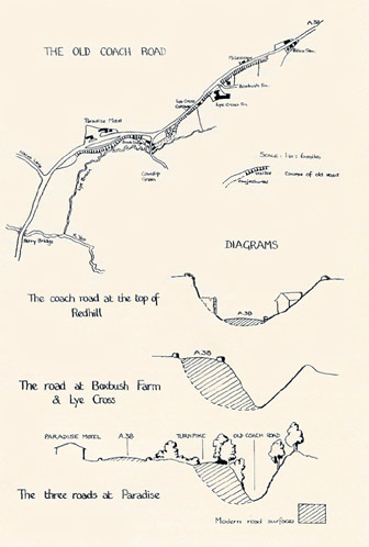
While this local history study-group was in progress, new road-widening works commenced on the A 38 at Redhill, in the parish. At one time there seemed a possibility that the visible remains of the old Coach Road might be filled in during this process. Although this has not in fact happened, the re-shaping of this stretch of road may continue for some months or years to come, and it seems timely to set on record what remains, today, of its predecessor . The A 38 is the modern representative of a very old through road from Broadfield Down, down Redhill and across the Wrington valley, one of the main links between Bristol, north Somerset and the southwest since medieval times. Rocque's maps of the Manor of Wrington in 1738-9 show it as an important road on much the same line as at present, though unmetalled and in places very wide. Repairs to Perry Bridge were noted in the paper Manorial Court Papers 1733-1757. Perry Bridge, crossing the Yeo at the foot of the hill, is also marked on John Ogilby's semi-pictorial routemap of the London-Bristol-Huntspill road in 1675. The name in fact suggests this crossing may be much older still : "perry" may be a corruption of the French "pierre" (stone), a stone bridge, as opposed to the plank (beam) bridge at the less important Beam Bridge crossing. The Bristol Turnpike Trust was set up in 1727 and took over this road as far as East Brent, levying tolls in order to pay for its upkeep. They planned, indeed, to re-route it through Wrington itself, and only the strong objections of Rev. Henry Waterland prevented this happening, for which piece of far-sightedness most present-day inhabitants should be most thankful. It was the Turnpike Trustees who, in the course of redesigning the road to cope with 19th century traffic, set up the present iron milestones, dated 1837. They probably replaced earlier stone ones. The old coach road up the hill, being unsurfaced, was worn very deep into the ground by sheer usage. It also became very wide, as coaches and waggons drove further and further over the verges in an effort to avoid the ruts in the centre of the road. It is this wide road, with its tremendous verges, that appears on the 1738-9 map of Wrington. This too is the road that can still be seen at the top of Redhill, above the Darlington Arms, the ground sloping up on each side, with 18th and 19th century farms and buildings with long narrow gardens, fitted on to the wide road verge. These verges would not have been needed for traffic once the Turnpike Trustees had put a stone surface on the road. Lower down the hill the modern road has been lifted out of this great "ditch" by embanking. The 19th and 20th century embankments were actually built in the old road, partially but not entirely filling it up, so that a deep ditch appears at one side of the present road. This represents the remains of the old coach road, reduced to less than half its original width, and it can be traced for a considerable distance down the east side of the present A 38. Nothing at all is visible on the west side, where the modern road has been blended into the adjoining field surface except where elaborate embankments are, once again, now being constructed. (see diagrams).
This copse, between the old road and the new one, is on a level with the present road surface and may simply be growing on the 19th century embankment. The old road is temporarily lost, either under this embankment or, if it plunged right down almost to Lye Brook, in the cottage gardens there. The latter seems more likely, as there are indications that it re-emerges from Brook Lodge's back garden. Moreover, Mr. and Mrs. House of Brook Lodge have said that the house opposite was in fact once the stable block attached to Brook Lodge itself. Such sizeable stabling suggests that Brook Lodge was sited on the old coach road, right at the bottom of Redhill - at a point where the need for fresh or additional horses for the steep pull uphill would ensure brisk trade ! When one views Brook Lodge from the present road a depression in the ground by the north-west corner of the garden wall does suggest that this is the line of the old road, having gone down to the stream-side, now curving back into the wood opposite the Paradise Motel - where, in its last stage, it becomes startlingly clear. The area opposite Paradise Motel is of particular interest as here three stages of the development of this road can be seen. There is the wide, smooth curve of the present MRS. F. NEALE. |
|||
![]()
![]()