|
Wrington Village Records Studies of the history of a Somerset Village A map of Wrington in 1738 Pages 39 - 41 |
|
|
Wrington Village Records Studies of the history of a Somerset Village A map of Wrington in 1738 Pages 39 - 41 |
|
|
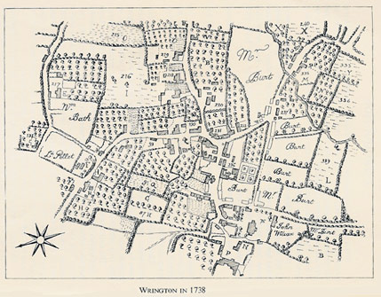
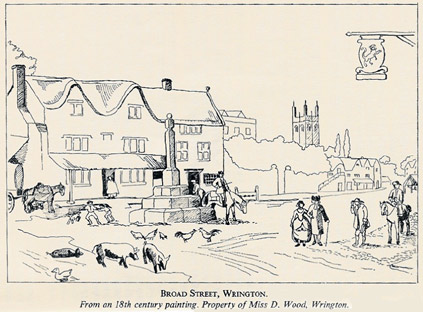
Sources: Map-" A Survey of Wrington Tything, belonging to the Rt. Hon. Wm. Pulteney, Esq., taken and drawn by John Rocque, 1738". Original map lent by Mr. P. F. Bennett, Wrington, and now in Bristol Records Office. (Ref 22160 (1 -3).) Illustration: see frontispiece. The map here described is one of a set of three maps of the Manor of Wrington. The largest (1739) covers the whole manor; while the others show two of the three subdivisions or tithings of the manor, Broadfield (1739) and Wrington (1738). This suggests that a fourth map, the tithing of Burrington (also part of the manor) originally completed the set, but this seems now to have disappeared. The best preserved of the three maps is that of Wrington Tithing, which includes the whole of the village: and it is this map which is the subject of the present study. Finely drawn on heavy parchment, at a scale of about 12 ins. : 1 mile, the map shows 18th century Wrington in considerable detail. Hedges, trees, orchards and woodland, roads and paths are all minutely drawn. Fields are marked with letters and numbers, suggesting that a book of reference, now lost, once accompanied the map. Without this reference book to act as a key, the value of the map is purely visua1 - but nonetheless, it shows the centre of the village clearly enough to provide a basis for comparing the village in 1738, with the village today. The second source is a charming watercolour of Broad Street, which from the costumes must be of much the same date as the map. It shows how vivid and valuable a purely topographical drawing, nothing remarkable perhaps in its own time, can be 200 years later. If we compare the 1738 map with recent maps, we find that the main road system is much the same. The roads leading into the village are as today, with the exception that Wrington Hill, as we now know it, is clearly shown as it leaves Ropers Lane but then peters out into the open hill land. Long Lane with the tree at Branches Cross is there. The road from Congresbury is labelled Waste Lane and not Westhay as it is to-day. The road from Langford, now Station Road, is marked, although just south of Beam Mill it took a different course from the present day one; there is however evidence of the old route - a high hedge and ditch veer off to the left of the modern road to correspond exactly with the line of this road shown on the 1738 map. There is also the road leading in from Cox's Green, while Cox's Green itself is shewn as a true and sizeable "green ". The two narrow passages, both known as the Dring (a very old word meaning an "alley") one off High Street, and one off Station Road, are both marked on the old map. We have not done any work on the field systems, but a brief comparison of the 1738 map and the present one shows that a number of fields are similar in size and shape, though it is obvious that in some cases the hedges have been removed and the fields enlarged. A lot of work could be done on this subject. Our main concern here is with the buildings. The central area of the village shows a concentration of buildings around the part known as the Triangle, which was of course near to the Church and the Manor House of Wrington. Although the Manor is clearly shown on the map, it had disappeared by 1754 (see paper The Manor and the Manor House). The present Court Farm is thought to contain some of the old stone. In what is now known as Broad Street is a further concentration of buildings around a much wider road than it is at present, the markets and fairs still in 1738 being held here. At the east end of Broad Street a circle marks the position of the Village Cross, and here is quite an assembly of property. Here the watercolour of 18th century Broad Street supplements the map. It shows the sign of the Golden Lion, while opposite the houses on the south side of the road stand much as today, save for their thatched gables (probably 17th century) and long thatched "porches", and an outside staircase leading up to a loft. The Old Rectory can be seen, set back in its grounds; the top floor, which has since been removed, shows above the trees. Wrington church tower is seen in the distance. There are many houses that appear on the 1738 map and which still stand today. We have been able to enquire into the history of only a few of them. Off High Street there is a group of houses known as the Haydens (see also paper Estreat roll of court fines, 1528). There are now three houses, of which the one nearest to the road was added at a later date. The other two, owned by Mrs. Colchester and Mrs. Middleton, were obviously one house and it is shown on the map. It must have been sizeable, and as it is high overlooking the village we wonder if it was owned by someone of importance. The range of cottages, now one dwelling, opposite the Congregational Church in Ropers Lane and owned by Mr. Bush, appears to be very old. Mr. Bush tells us the buildings were originally thatched, and in his garden have been dug up Roman coins and old clay pipe stems. The property known as The Old Bakery, and now owned by Mrs. Mansell, is also very old. The walls are thick and there are old beams. The area of garden and line of walling is today virtually the same as it was in 1738. It is said to have been one of the many Inns of Wrington, and was for a very long time a bakery ; it is only recently that the old ovens at the back have been removed and the property modernised. Mulberry Cottage, in Church Walk, is composed of two dwellings. In a will dated 1712, Elizabeth Strode gave the property to Joan Byrt (the name Burt appears on the old map). William and Francis Byrt sold the property to Frances Parry in 1740. It is obviously a very old property, with thick walls, and in one of the rooms there is still a part of the original plaster ceiling. The present owner, Admiral Taylor, is in possession of some very interesting old deeds and documents. Richard's Garage in Broad Street was, 12 years ago, "The BeJl Inn". The front of the property is not all that old and is said to have been a grain store added, like other buildings, when the market declined and the road space was no longer required; but A house is marked on the map at the bottom of the High Street Dring, and it is thought that this may be Southcombe, owned by Mr. and Mrs. James. The Mill, in Mill Lane, owned by Dr. Tricks, was certainly there when the map was drawn, and various differing mill leats are clearly shown. Miss E. P. CHAMBERS, MISS C. TRUMAN AND Miss E. M. WEST. |
||
![]()
![]()